Suvarna Garge (Editor)

Zorn (river)

Updated on
Edit
Like
Comment
Share on FacebookTweet on TwitterShare on LinkedInShare on Reddit
Reference no.
  
FR: A34-0200

Country
  
France

Basin size
  
757.2 km² .

River system
  
Rhine

Zorn (river) httpsuploadwikimediaorgwikipediacommonsthu

Location
  
France, regions of Lorraine and Alsace

Main source
  
In the central Vosges, in the department of Moselle ca. 830 m

River mouth
  
Near Rohrwiller into the Moder ca. 120 m

Progression
  
Moder → Rhine → North Sea

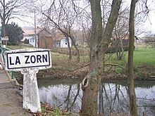
The Zorn is a river that flows through the Lorraine and the Alsace as the largest and last of the tributaries of the River Moder, before the latter empties into the Rhine. It rises on the territory of Walscheid as the Yellow Zorn (German: Gelber Zorn, French: Zorn Jaune) and becomes the Zorn after its confluence with the right-hand tributary, the White Zorn (Ge: Weißer Zorn, Fr.: Zorn Blanche). It has a length of just under 97 kilometres and drains an area of 757 km². The French spelling Zorn first surfaced in the 18th century. Hitherto the river was called the Sorn, which stems from the pre-Celtic era and probably meant "the flowing one". The upper reaches of the river as far as Saverne are viewed as having great, scenic beauty and are also home to many fine examples of architecture.

Contents

Map of La Zorn, France

Tributaries

  • White Zorn (right), 8.5 km
  • Treubach (left)
  • Mittbach (left)
  • Ruisseau de Dabo (right)
  • Fischbach (right)
  • Ruisseau de Heyerst (left), 3.7 km
  • Tiergartenbach (right), 3.7 km
  • Hesselgraben (left)
  • Stutzbach (left), 4.7 km
  • Ruisseau le Mundel (right), 1.6 km
  • Baerenbach (right), 11.3 km
  • Ruisseau de la Fontaine Mélanie (left), 4.5 km
  • Schlettenbach (left)
  • Michelsbaechel (left), 5.1 km
  • Liesgraben (left)
  • Liesmattgraben (left), 3.4 km
  • Southern Zinsel (rivière la zinsel du sud) (left), 30.9 km
  • Mossel (rivière la mossel) (right), 21.2 km
  • Horattgraben (right)
  • Lienbach (left), 9.5 km
  • Littenheimerbach (Morenthalgraben) (right), 3.1 km
  • Rohrbach (right)
  • Embsbaechel (Bachgraben) (left), 12.7 km
  • Gebolsheimerbach (left) (via the Landgraben 11.2 km)
  • Mattgraben (right), 1.2 km
  • Rissbach (left), 8.0 km
  • Seltenbach (left) (via the Hochstettergraben 9.6 km)
  • References

    Zorn (river) Wikipedia