
Listing Country high point Prominence 100 m | Elevation 2,534 m Mountain range Prokletije, Dinaric Alps | |
 | ||
Similar Dobra Kolata, Đeravica, Maja Jezercë, Bobotov Kuk, Maglić | ||
Zla kolata 2534m najwy szy szczyt czarnog ry 28 07 2015
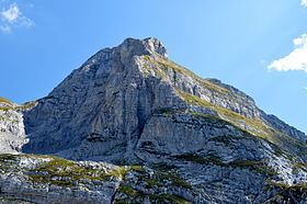
Zla Kolata (Montenegrin: Зла Колата, Zla Kolata; Albanian: Kollata e Keqe) is a mountain of the Prokletije on the border of Montenegro and Albania. It has an elevation of 2,534 metres (8,314 ft), making it the highest mountain in Montenegro, and the 16th highest in Albania. It is located on the border of the Plav municipality of Montenegro and the Tropojë district of Kukës County, Albania. Zla Kolata has an enormous summit and is a popular tourist destination in both countries. Standing half a kilometer to the northeast at 2,528 metres (8,294 ft), only slightly lower, is Kolata e Mirë or Dobre Kolata , also located on the border. The highest peak on this massif is a kilometer east-southeast of Zla Kolata and is completely on Albanian soil; called Rodi e Kollatës or Maja e Kollatës, it rises to 2,552 m (8,373 ft) but despite the dramatic views into the Valbona Valley, is not as often visited.
Contents
- Zla kolata 2534m najwy szy szczyt czarnog ry 28 07 2015
- Map of Zla Kolata
- 29 06 03 07 2016 prokletije i najvisi vrh crne gore vrh zla kolata 2534m n v
- References