
Country United States Elevation 843 ft (257 m) Zip code 46077 Population 25,115 (2013) | Time zone Eastern (EST) (UTC-5) Local time Saturday 9:19 PM Area code 317 | |
 | ||
Weather 10°C, Wind SE at 2 km/h, 67% Humidity | ||
Home for sale 550 w oak st zionsville indiana
Zionsville is a suburban town located in the extreme southeast area of Boone County, Indiana, United States, in Eagle Township, northwest of Indianapolis. The population was 14,160 at the 2010 census, and grew to 26,296 in the Census 2015 estimates.
Contents
- Home for sale 550 w oak st zionsville indiana
- Map of Zionsville IN 46077 USA
- History
- Geography
- Climate
- Airport
- Demographics
- 2010 census
- 2000 census
- In popular culture
- Shops
- Festivals
- Camps
- Education
- References
Map of Zionsville, IN 46077, USA
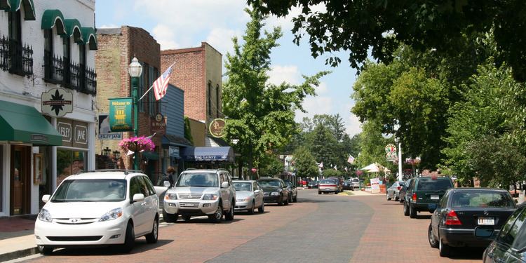
Zionsville promotes itself as a tourist attraction around its village-styled downtown area. This area primarily consists of Main Street, paved entirely in brick, which is lined with small stores and restaurants.
History
Zionsville was laid out in 1852 when the railroad was extended to that point. It was named for William Zion, a pioneer settler.
Abraham Lincoln made a whistle-stop speech in Zionsville in 1861 when traveling to his inauguration.
Town Hall (Castle Hall) was listed on the National Register of Historic Places in 1983.
Geography
Zionsville is located at 39°57′11″N 86°16′10″W (39.953092, -86.269462), approximately 15 miles (24 km) northwest of Downtown Indianapolis. According to the 2010 census, Zionsville has a total area of 10.298 square miles (26.67 km2), of which 10.26 square miles (26.57 km2) (or 99.63%) is land and 0.038 square miles (0.10 km2) (or 0.37%) is water.
Zionsville annexed 39.5 square miles (102.30 km2) of land after the 2010 Census, bringing the current area of the town to 49.7 square miles (128.72 km2) and adding 9,159 residents.
Climate
The climate in this area is characterized by hot, humid summers and cold winters. According to the Köppen Climate Classification system, Zionsville has a humid continental climate, abbreviated "Dfa" on climate maps. Its inclusion in this climatic type is because of its four distinct seasons, large ranges between high summer temperatures and low winter temperatures, and enough precipitation for it to not be considered arid or semi-arid.
Airport
Demographics
According to the 2006-2010 American Community Survey, the median income for a household in the town was $108,420, and the per capita income was $48,692. 3.0% of the population were estimated to be below the poverty line. The median value of owner-occupied housing units in the town was $355,800.
2010 census
As of the census of 2010, there were 14,160 people, 5,129 households, and 3,872 families residing in the town. The population density was 1,380.1 inhabitants per square mile (532.9/km2). There were 5,539 housing units at an average density of 539.9 per square mile (208.5/km2). The racial makeup of the town was 94.0% White, 1.2% African American, 0.1% Native American, 2.7% Asian, 0.5% from other races, and 1.4% from two or more races. Hispanic or Latino of any race were 2.1% of the population.
There were 5,129 households of which 44.1% had children under the age of 18 living with them, 66.9% were married couples living together, 6.5% had a female householder with no husband present, 2.1% had a male householder with no wife present, and 24.5% were non-families. 22.0% of all households were made up of individuals and 8.8% had someone living alone who was 65 years of age or older. The average household size was 2.75 and the average family size was 3.25.
The median age in the town was 39.6 years. 31.6% of residents were under the age of 18; 4.6% were between the ages of 18 and 24; 23.2% were from 25 to 44; 29.6% were from 45 to 64; and 10.9% were 65 years of age or older. The gender makeup of the town was 48.7% male and 51.3% female.
2000 census
As of the census of 2000, there were 8,775 people, 3,063 households, and 2,407 families residing in the town. The population density was 1,512.9 people per square mile (584.1/km²). There were 3,169 housing units at an average density of 546.4 per square mile (211.0/km²). The racial makeup of the town was 97.78% White, 0.33% African American, 0.11% Native American, 1.07% Asian, 0.32% from other races, and 0.39% from two or more races. Hispanic or Latino of any race were 0.97% of the population.
There were 3,063 households out of which 45.5% had children under the age of 18 living with them, 70.5% were married couples living together, 6.8% had a female householder with no husband present, and 21.4% were non-families. 19.1% of all households were made up of individuals and 7.5% had someone living alone who was 65 years of age or older. The average household size was 2.80 and the average family size was 3.23.
In the town, the population was spread out with 31.7% under the age of 18, 4.2% from 18 to 24, 27.8% from 25 to 44, 25.6% from 45 to 64, and 10.7% who were 65 years of age or older. The median age was 38 years. For every 100 females there were 93.1 males. For every 100 females age 18 and over, there were 86.8 males.
The median income for a household in the town was $81,770, and the median income for a family was $95,359. Males had a median income of $62,334 versus $35,823 for females. The per capita income for the town was $35,049.
In popular culture
Shops
Several blocks of Main Street in Zionsville have been intentionally groomed to give off a "village" air, specifically to attract shopping from nearby larger communities. In addition, Main Street has been paved entirely in brick and the street lamps and other features (such as a lower speed limit) are maintained to encourage visitors and residents to spend a good deal of time shopping on foot along the length of the street.
Festivals
One of Zionsville's seasonal attractions, the July Fourth fireworks show hosted by the local Lion's Club, brings in people from across Indiana. Unlike many of the Independence Day celebrations in major cities, the Zionsville fireworks show has no music integrated into the performance, although there are concerts before the display. There is also the Fall Festival which has a parade featuring sports teams, organizations from Zionsville and surrounding communities, and the Middle and High School marching bands. There is also a festival at the Lion's Park with attractions like rides, games, and food. It lasts for one weekend in September.
Camps
Zionsville contains the Goldman Union Camp Institute (or GUCI), a Jewish camp that is part of the URJ (Union for Reform Judaism).
Education
Zionsville Community School Corporation, which encompasses an area in Eagle Township extending beyond Zionsville town limits, enjoys a very strong reputation. For the past half decade, it has been ranked among the top five public school corporations in Indiana by Indianapolis Monthly magazine. Zionsville schools have rivalries with schools in neighboring Carmel, Lebanon, and Pike Township in Indianapolis. The superintendent of schools is Scott Robison, who joined Zionsville Community School Corporation in 2006.