
Type lake Max. length 0.275 km (0.171 mi) Surface area 38.4 ha (95 acres) Surface elevation 1,672 m | Basin countries Poland Max. width 0.238 km (0.148 mi) Max. depth 15.1 m (50 ft) Area 38 ha | |
 | ||
Similar Tatra Mountains, Długi Staw Gąsienicowy, Czarny Staw Gąsienicowy, Przełęcz między Kopami, Dwoisty Staw Gąsienicowy | ||
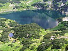
Zielony Staw Gąsienicowy (Polish: Zielony Staw Gąsienicowy) - a tarn part of the Gąsienicowe Ponds in the High Tatras; in Poland. The lake is located at an elevation of 1672 m.a.s.l. in a corrie by the Skrajna pyramidal peak. Formerly, the tarn was named Suczy Staw. Zielony Staw Gąsienicowy is the largest lake in the Zielona Gąsienicowa Valley.
Map of Zielony Staw, Zakopane, Poland
References
Zielony Staw Gąsienicowy (lake) Wikipedia(Text) CC BY-SA