
Mentioned 1817 Postal code 225101, 225102, 225110 Population 12,800 (2006) | Time zone EET (UTC+2) Area code(s) +375 1641 Local time Sunday 8:39 PM | |
 | ||
Weather 17°C, Wind S at 8 km/h, 53% Humidity | ||
Zhabinka (Belarusian: Жабінка, [ˈʐabʲinka]; Russian: Жабинка; Yiddish: זשאבינקע Zhabinke) it's a city in the southwestern region of Brest, Belarus. It is the administrative center of the Zhabinka District. The population is 12,900.
Contents
Map of Zhabinka, Belarus
History
The name of the place was first mentioned in Russian official papers in 1817.
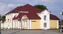
In 1882 a railway station was built here on the railway line that connected Warsaw, Brest and Moscow. It gave a powerful impetus to the development of the place. Within 2 decades it turned from a village into a town, attracting people of commerce, after the station boosted the economic development of the place.
For 125 years the town has been sprawling along the road from the railway station southwards to the highway Brest-Moscow, that is the major transcontinental traffic artery E30 today. After World War II a big sugar refinery was built north of the railway line. A big settlement appeared around it. Today Kirov Street starts form the railway station, runs across the town center with a big square and a park, further on southwards to the highway.
Geography
The town lies on the Mukhavets River at the confluence of the tiny Zhabinka River, that is rather a creek. There is the biggest in the district water reservoir Vizzhar (25 ha) in the western part of the town.
There is a big square and a park in the center of the town. The town occupies 9.11 km2.