
 | ||
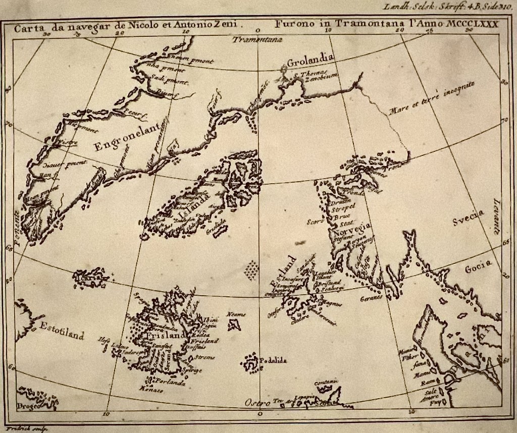
The Zeno map is a map of the North Atlantic first published in 1558 in Venice by Nicolo Zeno, a descendant of Nicolo Zeno, of the Zeno brothers.
Contents
The younger Zeno published the map, along with a series of letters, claiming he had discovered them in a storeroom in his family's home in Venice. According to Zeno, the map and letters date from around the year 1400 and purportedly describe a long voyage made by the Zeno brothers in the 1390s under the direction of a prince named Zichmni. Supporters of the Henry Sinclair legend suggest that Zichmini is a mistranscription of d'Orkney. The voyage supposedly traversed the North Atlantic and, according to some interpretations, reached North America.
Modern views
Most historians regard the map and accompanying narrative as a hoax, perpetrated by the younger Zeno to make a retroactive claim for Venice as having discovered the New World before Christopher Columbus.
The evidence against the authenticity of the map is based largely on the appearance of many phantom islands in the North Atlantic and off the coast of Iceland. One of these non-existent islands was Frisland, where the Zeno brothers allegedly spent some time.
Current scholarship regards the map as being based on existing maps of the 16th century, in particular:
Estotiland
"Estotiland" appears on the Zeno map, ostensibly on the western side of the Atlantic Ocean in the location of Labrador. Estotiland is listed along with Eden and Arcadia under the heading 'utopia, paradise, heaven, heaven on earth' in Roget's International Thesaurus. It is one of the sources for the Russian "Estoty", featured in Vladimir Nabokov's Ada.
Frisland
"Frisland" appeared on virtually all maps of the North Atlantic from the 1560s through to the 1660s. It is not to be confused with the similarly named Friesland in the Netherlands. It originally referred to Iceland ("Freezeland"), but after the Zeno Map placed it as an entirely separate island south (or occasionally south-west) of Iceland, it appeared that way on maps for the next 100 years.
Other islands
"Islanda" is clearly Iceland. "Estland" is presumed to be Shetland, with various place names recognisable as belonging to that island group. It has been tentatively suggested that "Podalida" is a corruption of Pomona, a historical name for Mainland, Orkney. "Icaria", or "Caria" if the initial "I" means "Island", has been suggested as a misplaced Kerry or Kilda, but may simply be an invention of the mapmaker. "Neome" has been identified as Fair Isle or Foula.