
Peak Róg | Elevation 715 m (2,346 ft) | |
 | ||
States Lower Silesian Voivodeship and Hradec Králové Region | ||
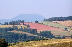
The Zawory Mountains with a height from 550 to 715 metres, are a wide and flat mesa in the Northern part of the Stołowe Mountains in the Central Sudetes, in South-Western Poland. Through the Zawory Mountains lies a continental divide of the North Sea and Baltic Sea, and the border with the Czech Republic. The name Zawory comes from the Polish word Zawora which means a closing.
Contents
Location
The Zawory Mountain range is located in the Southern part of the Polish border with the Czech Republic.
Specification
The Zawory Mountain range are forest-covered mountains which are characterised with a flat surface and steep mountain sides, with isolated hills which lay in the valley of the river Zadrna in the Krzeszowska Structural Basin which close up from the North and in the North-Western part of the Stołowe Mountains. The ridges of the mountains have sandstone surfaces. The mountain mesa surfaces are located on the Polish-Czech border. The Czech part the mountain range is called Závora. The border lies in between the ridges of the mesa, on the Polish side of the border are steep ridges and several branches which lead off to flat land, on the Czech side of the mountain range there are lower and more smoother falls into the valleys, which are cut through by valleys of streams, where in the centre the Adršpach-Teplice Rocks have been formed.
On the Polish side the mountain range has a shape of a twirl which stretches from the outskirts of Golińsk to the North-Eastern part of the Czech settlement of Police nad Metují in the South. The mountain range surrounds the Adršpach-Teplice Rocks from three sides. On the highest peaks of Róg, Drogosz, Chochoł, and Mielna, there are no formations of craig and tail, which normally are found in high amounts and different shapes of the steep ridges, especially in the Gorzeszowskie Rocks which are located under Gorzeszów and in the area surrounding Różana and Łączna. Due to the large amount of smooth land and ridges the territory of the mountain range is used as fields for crops where villages are located. Forests are located in the harder to reach areas, where there are steep ridges and in the parts of the mesa where there is ery steep terrain.
The highest peak of the mountain range is Róg having the height of 715 metres.
The highest peaks of the mountain range:
On the Polish side of the mountain range with border mountain peaks:
On the Czech side of the mountain range: