
Population 220 (2011) | Time zone CET (UTC+1) | |
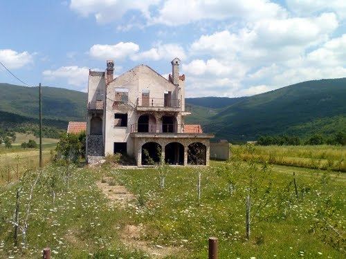 | ||
Zalužnica (Serbian Cyrillic: Залужница) is a village in the Gacka valley in Lika-Senj County, Croatia. It is located around the main road between the market town of Otočac and the Plitvice Lakes National Park. Over the last 100 years its population was around 700–1000 people but was de-populated in 1995 during the war that saw the breakup of the former Yugoslavia. A handful of old people remained in the village and a few new people have subsequently settled in the last 10 years.
Contents
Map of Zalu%C5%BEnica, Croatia
The village was probably established in the 17th century by peoples migrating from the Ottoman Empire in a territory then under the control of the Austro-Hungarian Empire. The existing village church dates to around 1770. During both the late 16th and 17th centuries the Ottomans had major offensives northwards. Many people fled ahead of them who were predominantly of the Christian Orthodox faith. The ethnicity of these peoples has been debated extensively, but from a simple review of family names they were seemingly a mix of mainly Serbs, Vlachs and various other minorities from Ottoman territories to the south. They settled in Lika and surrounding counties (such as Krbava); this was allowed by the Austro-Hungarian authorities to create a bulwark against future Ottoman incursions.
The Austro-Hungarian Army later maintained a presence in Otočac recruiting from both the Catholic Croat and Orthodox Serb communities in the surrounding area. This included the Otočac Border Regiment Nr.2 in the mid-19th century and the XIII Militärterritorial (Korps) bezirk, Otočac at the start of World War I.
Population
A survey from 1895 had the population at 1139 with 178 households. This was made up of the main village plus some smaller settlements, namely Draga Brakusa, Čelina, Gola Brdo and Cvijanovic kuca. This population probably represents the pinnacle in numbers as in the first decade of the 20th century many people left for the USA with millions of others from Europe, then there was the impact of the two World Wars (death and migration), from the early 1960s many younger people migrated to the cities and finally the wholesale migration of the village to Serbia in 1995 due to war. According to the 2011 census, there were 220 inhabitants living in 157 housing units. Based on anecdotal evidence from various visits to the village after this time, the actual number of permanent inhabitants is significantly lower, estimated as no more than 50.
Many village family names suggest a clan culture, which suggests their origin as Montenegrin, Bosnian and Serbian. A significant portion of the village had the family name of Hinić (Hinich). Other common family names include, Brakus, Borovac, Popovic, Uzelac, Vukovojac. As many of the households of the same family name were not related (in living memory) the practice of giving nicknames, called 'špicnamen' (German origin) to differentiate themselves, was widespread. This is particularly true of those named Hinić.
Language
Given the relative isolation, mixed origins, neighbouring Croats who spoke a different dialect (and accent) and the influence of the ruling Austro-Hungarian state, the language used by people in Zalužnica and other nearby Serb villages developed its own character. From an academic perspective the people spoke the Štokavian dialect and over-time mixed Ijekavian and Ekavian variants in every day language, which again reflects their origin e.g. in the mainly Serbian ekavian sub-class the word for 'milk' is 'mleko' compared to mljeko in the ijekavian form. Some words in an otherwise mainly shared south slav lexicon were different e.g. the Serbian 'hleb' for 'bread' compared to Croatian 'kruh'. Some Zalužnica villagers used the slang 'krua-leba'. German words (and corrupted forms) also became inter-mingled into everyday use, influenced by the direct Hapsburg rule until the end of WW1 e.g. German 'grau' for 'grey' as opposed to the Slavic 'siv', 'šnider' for 'tailor' instead of 'krojač', 'stoff' used for 'cloth' instead of 'tkanina'. There is also some latin based influence, which could originate from close by Venetian territories on the coast or from true vlachs e.g. 'čeno' for 'dog' instead of slavic 'pas'. The rural upland setting naturally stamped its own influences.
Surrounding area
The village is located around the main road running from Plitvice Lakes National Park to the east that leads to a crossroads at Čovići; turning northwest the road leads to Otočac and from there onto the coast to Senj, while turning south leads to Gospić. By car, it takes about 45 minutes to drive to Plitvice and 15–20 minutes to Otočac. The first village to the southwest towards Čovići is the village of Sinac (both Croat villages). Otočac was a mixed market town of Croats (majority) and Serbs (and on the outskirts of town a settlement of Roma).
North of the main road is a country lane where Zalužnica merges with Doljani and beyond that Škare and Podum (all Serb villages). East towards Plitvice, the first village is Vrhovine (mixed but mainly a Serb village), which is probably the highest above sea level in the immediate area (700m above sea level compared to Zalužnica's 500 m, only 10–15 minutes drive down the road). Vrhovine has a railway station. While there are a few households off the beaten track like Dugi Dol, there are no other settlements because to the immediate south, south-east and north east are mountain peaks. Zalužnica sits on the eastern slope of the Gacka valley; in the eastern part of the village by the main road is a limestone cavern and underground river, which, until the early 1950s, was a main drinking water supply for the village (later a number of common wells were dug around the village that tap into the same underground water supply).
Farming
Farming in Zalužnica was a matter of self-subsistence made difficult by the limestone geology and mountainous terrain. The mainstays of the average farm was sheep, cattle, pigs, wheat, barley, and potatoes. Plums orchards were a very important resource from which to make the local spirit called Šlivovic. The winters are typically harsh, and the summers are hot. Until the early 1960s, most work on the farm was manual throughout the year using bullocks/ox (or a few families who could afford to keep horses) as the main power source for heavy farm work. By the mid-1970s, farming became almost fully mechanised. Typical farm sizes were around 10 hectares with many small fields scattered around the village resulting from historical family inheritance customs, which further limited the scope for larger farmsteads. For those farms away from the main road electricity was only connected in the late 1950-60's and piped water in the 1970-80's.
History
From its establishment amidst conflict, the village and its people continued to be moulded by conflict throughout history. The main exceptions to this was the economic migration to the USA in the early 1900s and the relative prosperity of the 1960's and 1970's. The regular occurrence of war mainly destroyed whatever social documents existed between wars. What documentation has been found so far typically provides small snippets of tangential information and includes Austro-Hungarian army history and records (18th to 20th century), 19th century and early 20th century ecclesiastical and population surveys and Ellis island related information (1900 to 1920). Births, deaths and marriages and other social documents have yet to be sought as anecdotal evidence and opinion is that it is likely lost, even from the post-WW2 period.
Pre-1700s
The presence of a notable opening at ground level to an underground river and caverns would have attracted people through the ages. There is a obscure mention of Roman presence but whether that was within the general area of the village is open to question.
The local market town of Otočac has a history, it is believed, dating from around 1100. From 1300, Otočac became part of the Frankopan family estate, which possibly extended to include the area that became Zalužnica. Prior to Ottoman incursions, there was possibly a Croatian settlement believed to be called Zalug with two churches (pending further research), but it is certain the general area became de-populated and remained so for 150 years until Orthodox peoples started to settle.
Through the 1500s the Ottoman's progressively extended their empire immediately to the south of Otočac (Ottoman Lika) and Bosnia. This borderland stretching eastwards became the Hapsburg's Military Frontier, the Krajina, which was ruled directly from Austria. Catherine Wendy Bracewell's 'The Uskoks of Senj', usefully describes the nature of this borderland in its early days from around the 1520s. On expulsion of the Uskoks from Senj in 1618, some settled in Otočac, co-inciding with greater numbers of Orthodox settlers in the Gacka valley.