
Country Jordan Settled 2012 Area code(s) +(962)2 Area 5.2 km² Population 79,900 (2015) | Governorate Mafraq Governorate Time zone UTC+2 (UTC+2) Address Zaatari Village, Jordan Founded 28 July 2012 | |
 | ||
Weather 20°C, Wind W at 32 km/h, 36% Humidity | ||
Silver medallist samantha murray visits zaatari refugee camp in jordan camps to champs
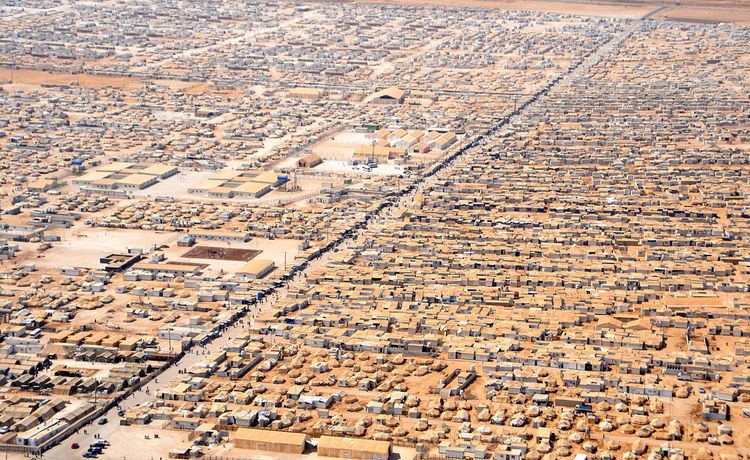
Zaatari (Arabic: مخيم الزعتري) is a refugee camp in Jordan, located 10 kilometres (6.2 mi) east of Mafraq which is gradually evolving into a permanent settlement. It was first opened on July 28, 2012 to host Syrians fleeing the violence in the ongoing Syrian civil war that erupted in 2011. On March 26, 2015, the camp population was estimated at 83,000 refugees.
Contents
- Silver medallist samantha murray visits zaatari refugee camp in jordan camps to champs
- DemographicsEdit
- Population growthEdit
- ServicesEdit
- MappingEdit
- References
It is connected to the road network by a short road which leads to the highway 10.
The camp features market-like structures along the main street where goods like vegetables, basic household equipment and clothes can be purchased. There are also coffee shops where shisha can be smoked.
Since the opening of the camp in July 2012, the camp population has repeatedly demonstrated. The main concern has related to the lack of sufficient food supplies and better accommodation. The camp has seen an increasing number of reports of crime, including prostitution and drug-dealing. Furthermore, demonstrations are used as a forum to create awareness of the conflict and to express political views against the current government led by Bashar al-Assad and the violence inflicted by the Syrian Armed Forces. Further the protesters declared support for the Free Syrian Army.
Due to the maximum capacity of 60,000 refugees in March 2013 a second camp was built 20 kilometres east of Zarqa in the Marjeeb Al Fahood plains. On 5 April 2014 a riot resulted in a number of injuries to both refugees and Jordanian police. One refugee was killed by gunshot.
In 2015, filmmakers Zach Ingrasci and Chris Temple lived in Zaatari for a month, resulting in the documentary Salam Neighbor.
DemographicsEdit
Accurate counting of the number of refugees in the camp stopped during March 2013 due to the high influx of refugees that skyrocketed that month. Current estimates put the number of refugees residing in the camp at about 79,900 (August 23, 2015 estimate).
Population growthEdit
Since the opening of the refugee camp in July 2012, the camp saw a dramatic increase in its population, that made it the largest population center in Mafraq Governorate within a few months:
The figures during the initial days varied slightly from day to day due to people 'escaping' or leaving the camp back to Syria, and partly due to initial over counting Movement out of the camp remains restricted leaving many to label it a prison or detainment camp and going against core humanitarian principles. Most of the refugees are from the Governorates of southern Syria, Damascus and Homs.
ServicesEdit
UNHCR remains responsible for the refugees and the camp is managed by the Jordanian Hashemite Charity Organization / JHCO. In March 2013 the UNHCR called the German Mr Kilian Kleinschmidt to be the "Senior Field Coordinator" of the camp. Other actors include:
Community mobilization:
Medical:
WASH (Water/Sanitation/Hygiene) coordination and overall responsibility:
Water and sanitation facilities:
Food:
Hygiene Promotion:
Education:
Women's and Children's Protection:
Others
The Zaatari refugee camp is gradually moving away from a model of top-down service provision, as is usual with refugee camps administered by international humanitarian organisations. Instead, under the aegis of the UNHCR, the camp is gradually transforming into a self-provisioning urban conglomeration, where refugees are provided with various forms of cash-based assistance and encouraged to address their own needs.
MappingEdit
Since 2012 Zaatari shelters and other structures have been mapped more than 25 times using satellite imagery by UNOSAT. Zaatari is one of the first camps to be mapped in detail through OpenStreetMap.