
Population 516 (1999) | Area 3.4 km² Local time Sunday 10:50 AM | |
 | ||
Intercommunality Communauté de communes du Vimeu Industriel Weather 16°C, Wind SE at 8 km/h, 65% Humidity | ||
Yzengremer is a commune in the Somme département in Hauts-de-France in northern France.
Contents
Map of 80520 Yzengremer, France
Geography
Yzengremer is situated 15 miles (24 km) west of Abbeville, on the D19 road. It is located 7.5 kilometres from the Channel coast, near the former Route nationale 25 (now RD 925) between Abbeville and Tréport.
Access to the village can be made from the autoroutes A16 (Paris-Dunkerque) and A28 (Abbeville-Rouen).
Economy
The economy is based around agriculture, including cereals, sugar beet, fodder and cattle.
Sites and monuments
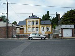
The commune contains the Eglise Saint-Médard, which is dated to the 15th century, and a 17th-century château, a rectangular brick and stone building flanked by a single wing at right angles. A front-central section of each facade was added in the 19th century. An old locksmith works, dating from the late 19th to mid-20th century, is listed on the French Ministry of Culture's inventory of cultural heritage along with the gardens of the Château d'Yzengremer.