
Canton Sciez Area 3.12 km² INSEE/Postal code 74315 /74140 | Time zone CET (UTC+1) Population (2014)2 925 Area1 3.12 km2 (1.20 sq mi) | |
 | ||
Intercommunality Communauté de communes du Bas-Chablais Elevation 372–441 m (1,220–1,447 ft) | ||
Yvoire lac leman
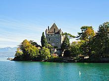
Yvoire is a small medieval town in Haute-Savoie department, in the region of Auvergne-Rhône-Alpes in south-eastern France.
Contents
- Yvoire lac leman
- Map of 74140 Yvoire France
- Le village m di val d yvoire
- Geography
- Features
- History
- References
Map of 74140 Yvoire, France
Le village m di val d yvoire
Geography
Located at the tip of the Leman peninsula (presqu'île de Léman), Yvoire delimits the two main parts of Lake Geneva, the "petit lac" and the "grand lac".
Features
It is well known for its medieval buildings and beautiful flower decorations during the summer season, and also Jardin des Cinq Sens, a garden in the center of the town. It is one of the "most beautiful villages of France".
History
The town was fortified by Amadeus V in the 14th century. It soon gained a strategic military importance and the inhabitants were given tax privileges.
References
Yvoire Wikipedia(Text) CC BY-SA