
 | ||
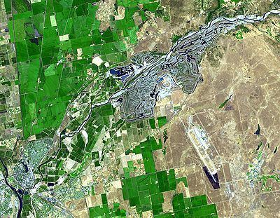
Yuba goldfields yuba river aerial view
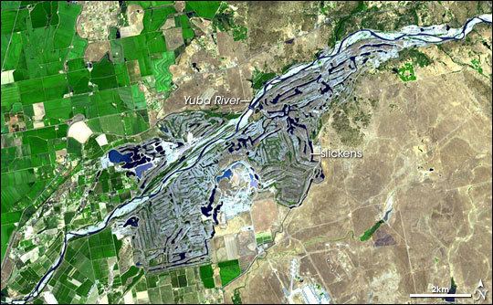
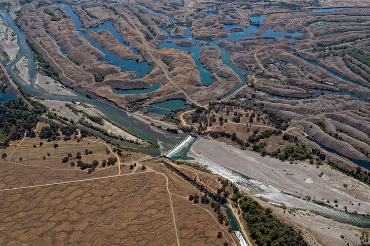
The Yuba Goldfields is a valley of 10,000 acres (40 km2) on both sides of the Yuba River in Yuba County, California, located northeast of Marysville. The goldfields are noted for their otherworldly appearance, filled with oddly shaped gravel mountains, ravines, streams and turquoise-colored pools of water. From the air, the goldfields are said to resemble intestines.
Contents
- Yuba goldfields yuba river aerial view
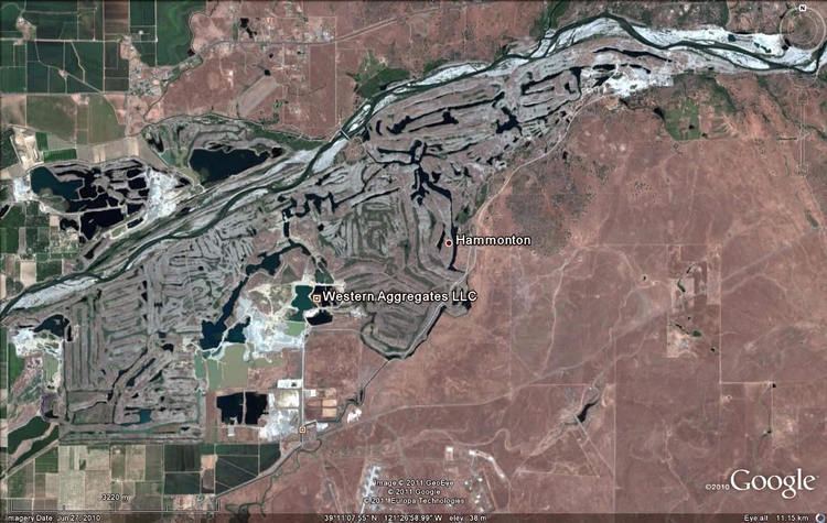
- Yuba goldfields dredge
- History
- Land controversy
- Environmental role
- Possible nature reserve
- References
Wild turkeys, deer, ducks, Beavers, herons, bald eagles, Northern river otters and even mountain lions now call the goldfields home.
Yuba goldfields dredge
History

They were created during the California Gold Rush. The first Yuba-area miners panned for gold in stream beds in the valley but within a decade large-scale industrial processes replaced solitary prospectors. Mining companies moved from the valley floor into the Sierra Nevada foothills, where miners blasted gravel hillsides with high-pressure jets of water—a process called hydraulic mining. After the miners extracted gold in long wooden sluices, they dumped the gravel back into the mountain valleys. Rivers and streams carried the flood of sediment—called slickens—down to the Sacramento Valley. Anywhere between 326,000,000 cubic feet (9,200,000 m3) to 685,000,000 cu ft (19,400,000 m3) of debris was deposited in the Yuba River. The mine waste carried by the Yuba River ended up raising the riverbed (by up to 100 feet (30 m) in some cases), causing floods that buried farms east of the town of Marysville with gravel, mud, as well as mercury and arsenic (byproducts of the mining process). As the Yuba River is a tributary of the Sacramento River, much of that debris then found its way to the San Francisco Bay. In Sacramento, the I Street Bridge had to be raised twenty feet (6 m). Lawsuits by farmers curtailed hydraulic mining in 1883, but the gravel remained behind in the Yuba Goldfields.
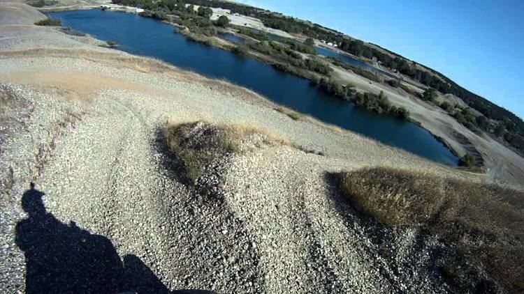
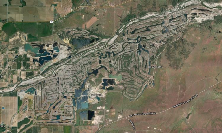
In 1893, the California Debris Commission began to dredge the Yuba near Marysville to mitigate the environmental damage, and piled the gravel along the river's banks, creating the irregular hills seen today. The dredgers also created over 200 ponds, which are fed by a network of underground rivers, which in turn were formed due to the porosity of the ground. The water in these ponds is usually clear blue, the impurities having been filtered by the gravel. The Debris Commission also built both the Englebright Dam to the east and the Daguerre Point Dam west of the goldfields to trap debris caused by hydraulic mining.
In the twentieth century, a series of mining companies reprocessed the slickens, extracting gold that was increasingly difficult to separate from the gravel. Even though the ore had already been processed, it was the principal source of gold in California for some time. Two mining towns, Hammonton and Marigold, were founded to house the gold miners and their families, but have been largely abandoned since 1957. By the 1970s, it was economically impossible to retrieve any more gold, and the debris became a source of aggregate, an essential ingredient of concrete. It has been estimated that up to $15 billion worth of aggregate lies within the goldfields, although the mining industry disputes this figure.
The environmental damage caused by the dredgers is enormous. The top 150 feet (46 m) of many square miles was turned upside-down. The soil and the rocks were separated with the rocks stacked on top of the soil.
Land controversy
The goldfields are the subject of an ongoing dispute as to land title and access. Much of the land is owned by Western Aggregate, a mining company extracting gravel from the goldfields. The remainder of the land is split between small private owners, the Bureau of Land Management, and the United States Army Corps of Engineers.
The BLM land is free for the public to use for recreational purposes, but much of it is actually unreachable. Some of it can be accessed via boats on the river, but other access roads have been closed off by Western Aggregate. The parcel of land owned by the Army Corps is technically public land, but it is also inaccessible and it is closed for recreation. Western Aggregate owns mining rights over much (but not all) of that property as a result of a purchase from a gold mining company in 1987 by its parent company Centex Construction, based in Texas. The Goldfields is the largest aggregate mine in the State of California, as well as one of only two dredge gold-mining operations in North America (as of 1989).
The titles themselves are also under much dispute because mining has so shifted the landscape of gravel as well as the river itself that it has become unclear as to what the property boundaries are.
In response to the blocking of Hammonton Road, a county road, into the Yuba Goldfields, the Yuba Goldfields Access Coalition was formed in 1996 by local historian Chuck Smith and neighboring landowner William Calvert. Smith, along with Goldfields residents and 80 members of the community, spent the next 10 years fighting for public access, arguing that the road had been public since 1850, when it was used by gold miners. Dozens of members of the coalition were arrested for trespassing on the public road, although none was convicted. In 2000, Yuba County Superior Court Judge Dave Wasilenko ruled that Hammonton Road was a public road, a decision ultimately upheld by the California Supreme Court in 2002. Two mining company owners were arrested for blocking a public road, and one mining company owner was arrested for threatening protestors with a handgun during the years-long dispute.
Environmental role
In the Central Valley, the Yuba is one of two rivers where Chinook salmon spawn, and the only one that supports steelhead trout runs. Salmon die when they reach fresh water, and their carcasses pile up in the goldfields, where turkey vultures hope to scavenge.
Possible nature reserve
There is currently a movement to establish a nature reserve on the lower Yuba River, which would include portions of the Yuba Goldfields. However, sorting out the land issue could take years. Creating a reserve would also require a large amount of money, but the aggregate could cover much if not all of that. As of September 2016, discussions are still ongoing, with the latest proposal being a habitat restoration project led by the United States Fish and Wildlife Service.