
OS grid reference SK197849 Post town HOPE VALLEY Postcode district S33 | Sovereign state United Kingdom | |
 | ||
Similar Win Hill, Bamford Edge, Ladybower Reservoir, Derwent Reservoir, Crook Hill | ||
Yorkshire bridge inn superb peak district hotel
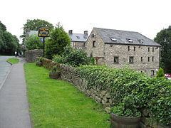
Yorkshire Bridge is a small hamlet at grid reference SK200850 near the Ladybower Reservoir dam in the English county of Derbyshire. Administratively the area forms part of the civil parish of Bamford and the district of High Peak. It is in the civil parish of Bamford. The people who built the Ladybower Dam wall lived in the houses at Yorkshire Bridge.
Contents
- Yorkshire bridge inn superb peak district hotel
- Storm frank north yorkshire bridge collapses due to flooding
- References
The settlement is named after a packhorse bridge, which crosses the River Derwent to the south of the dam of the Ladybower Reservoir from which the river has emerged and north of the village of Thornhill.
It has also given its name to a public house on the nearby A6013 road that is popular with walkers. The Derwent Valley Heritage Way has its northern terminus in the woods overlooking the reservoir.