
Length 121 km | ||
 | ||
Main source East Fork Yentna River andWest Fork Yentna RiverMatanuska-Susitna Borough, Alaska200 ft (61 m) River mouth Susitna River; Matanuska-Susitna Borough, Alaska; 26 ft (7.9 m); 61°33′38″N 150°29′4″W / 61.56056°N 150.48444°W Coordinates: 61°33′38″N 150°29′4″W / 61.56056°N 150.48444°W Sources Yentna Glacier, Mount Dall | ||
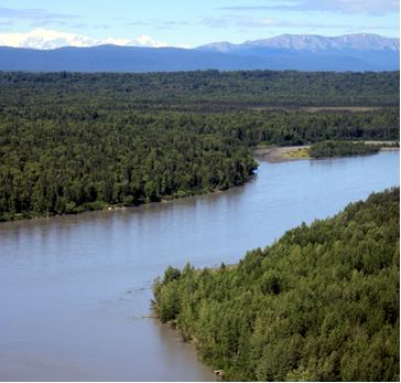
Upper yentna river
The Yentna River is a river in South Central Alaska, formed by its East Fork and West Fork at 62°16′50″N 151°46′26″W, flows South-East to Susitna River, 30 miles (48 km) North-West of Anchorage, Alaska; Cook Inlet Low.
Contents
- Upper yentna river
- Map of Yentna River Alaska USA
- Mystery creek off the yentna river in alaska 2010
- History
- Watershed
- Tributaries
- References
Map of Yentna River, Alaska, USA
Mystery creek off the yentna river in alaska 2010
History
Tanaina Indian name reported by Spurr (1900, p. 46), United States Geological Survey. "Sometimes called Johnson River after the first white man to ascend it."
Watershed
It begins in the Mount Dall and Yentna glacier systems and flows southeast to the Susitna River 2 miles (3.2 km) north of Susitna. The river system (including upstream tributaries) is about 100 miles (160 km) long.
Tributaries
From mouth to source:
Lake Creek just about 8 miles down river from Bottle Creek. Major fishing area: kings, reds, silvers. Winter sports, hunting. Moose Creek, Indian Creek, Fish lakes Creek, Hewitt Creek, Malone's Slough, Donkey Creek, Johnson Creek, Clearwater Creek, Rich Creek, Flag Creek, Delta Creek, Fourth of July Creek, & Kichatna River round out the rest of the main Yentna River Tributaries.