
1802–1925 → Disestablished 1 August 1925 | Established 27 February 1802 Political subdivisions uezds 8 (9 1874–85) | |
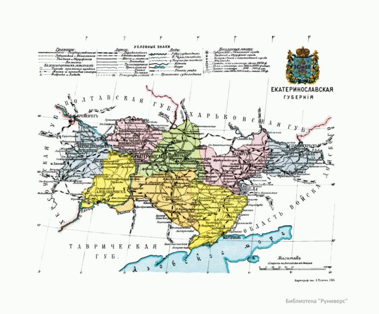 | ||
The Yekaterinoslav Governorate (Russian: Екатеринославская губернiя; translit.: Yekaterinoslavskaya guberniya; Ukrainian: Катеринославська губернія) or Government of Yekaterinoslav was a governorate in the Russian Empire. Its capital was the city of Yekaterinoslav (modern Dnipropetrovsk). Its territory lies within what is now Ukraine.
Contents
Location
The government was created in 1802 out the Yekaterinoslav vice-regency. It is located within the former lands of Zaporizhian Sich. The governorate bordered to the north with the Kharkov Governorate and Poltava Governorate, to the west and southwest with the Kherson Governorate, to the south with the Taurida Governorate and Sea of Azov, and to the east with Don Host Oblast.
Administrative divisions
The governorate was created in place of Novorossiysk Governorate in 1802 and encompassed a huge area of the southern Ukraine. Officially, the new governorate was created as Ekaterinoslav Governorate in 1802 and subdivided into the following uyezds with centres in:
- Yekaterinoslav (Екатеринославъ, Катеринослав) 1802–1923
- Pavlograd (Павлоградъ, Павлоград) 1802–1923
- Bakhmut (Бахмутъ, Бахмут) 1802–1920 transferred to Governorate of Donetsk
- Novomoskovsk (Новомосковскъ, Новомосковськ) 1802–1923
- Mariupol 1802–1807, 1874–1923 (1807–1874 part of Aleksandrovsk as Greek district)
- Aleksandrovsk (Александровскъ, Олександрівськ) 1805–1920 transferred to Governorate of Zaporizhia, created from both Mariupol and Pavlohrad
- Slavyanoserbsk (Славяносербскъ, Слав'яносербськ) 1805–1920 created out Bakhmut, transferred to Governorate of Donetsk
- Verkhnodneprovsk (Верходнѣпровскъ, Верхньодніпровськ) 1805–1923, created out Yekaterinoslav uyezd
- Taganrog 1805–1887, 1918 (1887–1918 part of Don Host Oblast)
- Taganrog city (Таганрог) 1802–1887
- Rostov upon Don city 1802–1887
Changes in Russian Empire
Ukraine
South Russia
Soviet Ukraine
Okrugs
List of okruhas of Ukraine upon the dissolution of the Governorate:
- Yekaterinoslav
- Zaporizhia
- Kryvyi Rih
- Melitopol
- Pavlohrad
Demographics
The governorate's population, a majority of peasants, was 662,000 in 1811, 902,400 in 1851, 1,204,800 in 1863, and 1,792,800 in 1885. From the second half of the 19th century, with the founding of Yuzovka (Donetsk), the governorate became the coal-mining and metallurgical center of the then Ukraine, incorporating the Dnieper Industrial Region and the Donbass (Donets Basin).
Its population increased to 2,113,674 by 1897. The nationalities within the governorate were: Russians (then divided into archaic categorisation of Little Russian (i.e. Ukrainian) speakers – 68.9% and Great Russian speakers – 17.3%), Jews (4.7%), Germans (3.8%), Greeks (2.3%), and Tatars (0.8%). In 1924, the governorate had 3,424,100 (13.6% urban) inhabitants, living in 5,165 settlements, 36 of them being cities and urban-type settlements. The largest social class was that of workers (about 25%).
Principal cities
The data is taken from demoscope.ru. Here is also the most common language composition.
From the turn of the 19th century until 1887 city of Rostov-na-Donu and all the Taganrog uyezd were part of the governorate, but before the census of 1897 took place they were transferred to the Don oblast. Note that the biggest city of the guberniya was the city of Rostov-na-Donu while Taganrog was not much smaller and the third in size. Here is the data on them: