
Local time Monday 2:32 AM | Area 724 km² Elevation 2,265 m (7,431 ft) | |
 | ||
Time zone Colombia Standard Time (UTC-5) Weather 13°C, Wind W at 3 km/h, 100% Humidity | ||
Yarumal is a municipality in the Antioquia Department, Colombia.
Contents
Map of Yarumal, Antioquia, Colombia
The municipality (3 parishes and 20 villages) has an area of 724 km², 35,315 inhabitants, and its average elevation is 2,265 m above sea level.
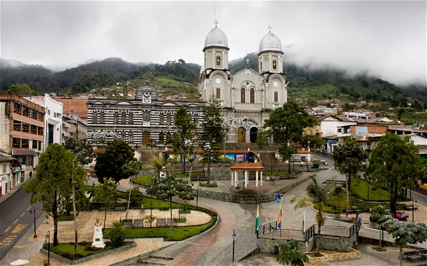
It has a minor basilica, Our Lady of Mercy, which is a parish church of architectural note.
It gave its name to the Yarumal Society for the Foreign Missions (M.X.Y./I.M.E.Y.), a Medellin-based Latin Catholic Society of Apostolic Life of Pontifical Right for Men, which despite its name is especially active in Colombian missions.
History
Yarumal was founded in 1787 as San Luis de Gongora. Municipal status was granted in 1821.
Name
The current name of Yarumal comes from a local plant belonging to the Moraceae family, known in botanical Latin as Cecropia peltata L.
Health
An unusually large proportion of the inhabitants suffer from early-onset Alzheimer's disease, which is caused by a genetic mutation. The genetic mutation is thought to have come from a Spanish conquistador. Approximately 5,000 residents will develop early-onset Alzheimer's. Half of the affected residents were shown to have developed symptoms by their early 40s.