Country China Website www.yantian.gov.cn Province Guangdong Province Prefecture Shenzhen | Time zone China Standard (UTC+8) Area 72.63 km² Area code 0755 | |
 | ||
Points of interest OCT East, Dameisha Beach, East Oversea Chinese, Shenzhen Ocean World, Wood Coaster | ||
yantian district of shenzhen city guangdong in cantonese flashcard
Yantian District (simplified Chinese: 盐田区; traditional Chinese: 鹽田區; pinyin: Yántián Qū; Cantonese Jyutping: Jim4 Tin4 Keoi1) is one of the six districts of the city of Shenzhen, Guangdong, China. It is adjacent to Shenzhen River to the south, and is surrounded by Luohu and Longgang districts of Shenzhen. Until March 1998, Yantian was part of Luohu District.
Contents
- yantian district of shenzhen city guangdong in cantonese flashcard
- Map of Yantian Shenzhen Guangdong China
- Subdistricts
- Industrial zone
- Tourist attractions
- Transportation
- References
Map of Yantian, Shenzhen, Guangdong, China
Subdistricts
The size of Yantian district is about 72.63 km². It contains four subdistricts:
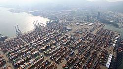
Located on Mirs Bay, Yantian is the location of some of Shenzhen's best-known tourist beaches, Dameisha and Xiaomeisha. Yantian Port is also located within the district.
Industrial zone
The Shenzhen Yantian Port Free Trade Zone was set up and approved by the State Council on September 27, 1996 with a total area of 0.85 square kilometer. On August 16, 2004, the project of "zone-port interaction" was approved by the State Council between Yantian Port and the Shenzhen Yantiangang Free Trade Zone.
Yantian Port Bonded Logistics Park was established with 0.96 square kilometer on December 30, 2005. The zone is situated near Yantian Port. Industries that are encouraged include printing/publishing/packaging, raw material processing, shipping/warehousing/logistics, and trading and distribution.
Tourist attractions
Transportation
The proposed Shenzhen Metro Yantian Line will be built to help serve the area.
