
- elevation 8,600 ft (2,621 m) - elevation 5,915 ft (1,803 m) - max 3,360 cu ft/s (95 m/s) Basin area 489.5 km² | - average 199 cu ft/s (6 m/s) - min 10 cu ft/s (0 m/s) | |
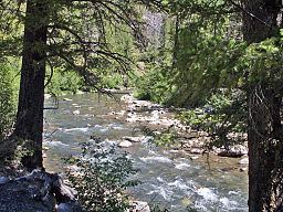 | ||
The Yankee Fork Salmon River is a 28-mile (45 km) tributary of the Salmon River in Custer County, Idaho in the United States. It originates in the Salmon River Mountains, in the Salmon-Challis National Forest, and flows south to its confluence at Sunbeam, about 10 miles (16 km) east of Stanley.
Map of Yankee Fork, Idaho, USA
References
Yankee Fork Salmon River Wikipedia(Text) CC BY-SA