
County Caswell Time zone Eastern (EST) (UTC-5) Zip code 27379 Population 2,014 (2013) | State North Carolina Elevation 617 ft (188 m) Area code(s) 336 Local time Sunday 11:21 PM | |
 | ||
Weather 12°C, Wind N at 2 km/h, 56% Humidity | ||
Yanceyville, first incorporated in 1833, is the county seat of Caswell County, North Carolina, United States. The population was 2,039 at the 2010 census.
Contents
Map of Yanceyville, NC, USA
History
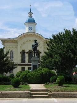
It has been the county seat since 1792 (although the settlement was originally called Caswell Court House until 1833). The original Caswell County Courthouse has been renovated and provides offices for county departments. The modern court house is located a few blocks north.
There remains uncertainty as to the person for whom Yanceyville is named. Some say it is named for James Yancey (1768–1829). Others claim it is named for his younger brother, Bartlett Yancey, Jr. (1785-1828). A few believe the name honored the entire Yancey family, long prominent in the area.
In addition to the Caswell County Courthouse, the Graves House, William Henry and Sarah Holderness House, John Johnston House, Poteat House, Bartlett Yancey House, Yanceyville Historic District, and Melrose/Williamson House are listed on the National Register of Historic Places.
Geography
Yanceyville is located at the center of Caswell County, at 36°24′25″N 79°20′30″W (36.407037, -79.341545). U.S. Route 158 passes through the town, leading east 22 miles (35 km) to Roxboro and west 22 miles (35 km) to Reidsville. North Carolina Highway 86 joins US 158 in a short bypass just north of the center of town and leads 29 miles (47 km) southeast to Hillsborough and 13 miles (21 km) north to Danville, Virginia. North Carolina Highway 62 passes through the eastern side of Yanceyville, leading northeast 12 miles (19 km) to Milton and south 25 miles (40 km) to Burlington.
According to the United States Census Bureau, Yanceyville has a total area of 5.6 square miles (14.4 km2), of which 5.5 square miles (14.3 km2) is land and 0.04 square miles (0.1 km2), or 0.57%, is water.
Demographics
As of the census of 2000, there were 2,091 people, 658 households, and 400 families residing in the town. The population density was 450.9 people per square mile (174.0/km²). There were 748 housing units at an average density of 161.3 per square mile (62.2/km²). The racial makeup of the town was 44.29% White, 53.99% African American, 0.33% Native American, 0.14% Asian, 0.33% from other races, and 0.91% from two or more races. Hispanic or Latino of any race were 1.00% of the population.
There were 658 households out of which 29.3% had children under the age of 18 living with them, 33.0% were married couples living together, 24.3% had a female householder with no husband present, and 39.2% were non-families. 36.8% of all households were made up of individuals and 19.0% had someone living alone who was 65 years of age or older. The average household size was 2.21 and the average family size was 2.88.
The population consisted of 19.6% under the age of 18, 8.4% from 18 to 24, 32.9% from 25 to 44, 20.8% from 45 to 64, and 18.3% who were 65 years of age or older. The median age was 37 years. For every 100 females there were 126.1 males. For every 100 females age 18 and over, there were 138.6 males.
The median income for a household in the town is $14,517, and the median income for a family is $20,125. The per capita income for the town was $10,430. Approximately 48.8% of families and 51.2% of the population live below the poverty line, including 69.5% of those under age 18 and 36% of those over age 65. An estimated 28.9% of whites live below the poverty line, whereas an estimated 63.8% of African Americans live below the poverty line.
In 2010, Yanceyville had the seventh-lowest median household income of all places in the United States with a population over 1,000.
Activities
Yanceyville features an antebellum courthouse designed by William Percival, and 23 other buildings, most built between 1830 and the Civil War, including a history museum and the Yancey House. Between its amphitheater and town square it annually hosts the "Bright Leaf Hoedown". The "Hoedown" is a one-day outdoor festival held in late September featuring local food vendors, live entertainment, crafts and non-profit organizations, usually drawing more than 5,000 guests.
Yanceyville also hosts the Caswell County Parks and Recreation Department, which features a variety of sports and activities, especially for children, and the Caswell County Civic Center, a full-size, professionally equipped stage, 912-seat auditorium, meeting and banquet facilities for up to 500, lobby art gallery and accessories which has concerts, plays and social functions. The town also has the county's senior center with recreational and fitness facilities built in 2009.