
Native name Дьааҥы/Džaangy Basin area 238,000 km² River mouth Laptev Sea; 0 m (0 ft) Mouth elevation 0 | Length 872 km Source elevation 132 m Country Russia | |
 | ||
Main source Confluence of Sartang and Dulgalakh Discharge Average rate:
25 m/s (880 cu ft/s) Basin size 238,000 km2 (92,000 sq mi) | ||
The Yana River (Russian: Я́на; [ˈjanə]; Yakut: Дьааҥы, Cáŋı), is a river in Sakha in Russia, located between the Lena to the west and the Indigirka to the east.
Contents
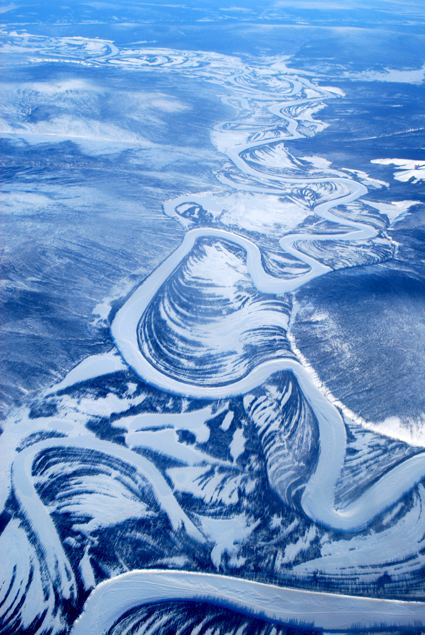
Map of Yana River, Russia
Course
It is 872 kilometres (542 mi) long, while the upper Yana is 1,320 kilometres (820 mi) long. Its drainage basin covers 238,000 square kilometres (92,000 sq mi), and its annual discharge totals approximately 25 cubic kilometres (20,000,000 acre·ft). Most of this discharge occurs in May and June as the ice on the river breaks up. The Yana freezes up on the surface in October and stays under the ice until late May or early June. In the Verkhoyansk area, it stays frozen to the bottom for 70 to 110 days, and partly frozen for 220 days of the year.
The river begins at the confluence of the rivers Sartang and Dulgalakh. As the Yana flows into the Yana Bay of the Laptev Sea, it forms a huge river delta covering 10,200 square kilometres (3,900 sq mi). Yarok is a large flat island located east of the main mouths of the Yana.
There are approximately 40,000 lakes in the Yana basin, including both alpine lakes formed from glaciation in the Verkhoyansk Mountains (lowlands were always too dry for glaciation) and overflow lakes on the marshy plains in the north of the basin. The whole Yana basin is under continuous permafrost and most is larch woodland grading to tundra north of about 70°N, though trees extend in suitable microhabitats right to the delta.
The principal tributaries of the Yana are: Adycha, Oldzho, Abyrabyt, Bytantay. Most of these tributaries are short rivers flowing from the high Verkhoyansk Mountains.
Verkhoyansk, Batagay, Ust-Kuyga, Nizhneyansk are the main ports on the Yana.
The Yana basin is the site of the so-called Pole of Cold of Russia, where the lowest recorded temperatures in the Northern Hemisphere are found. In the winter, temperatures in the centre of the basin average as low as −51 °C (−60 °F) and have reached as low as −71 °C (−96 °F) though in the mountains it is believed that temperatures have reached −82 °C (−116 °F). Yakut folklore says that, at such temperatures, if you shout to a friend and they cannot hear you, it is because the words have frozen in the air. However, when spring comes the words "thaw" and one can hear everything that was said months ago.
History
The Yana River area is the first known site of human habitation in the Arctic, with evidence of habitation found in the delta from as early as 30,000 years ago (12,000 years before the height of the last period of glaciation, or the Last Glacial Maximum).
In 1633–38 Ilya Perfilyev and Ivan Rebrov sailed down the Lena and east along the Arctic coast to the mouth of the Yana and reached the Indigirka River estuary. In 1636–42 Elisei Buza followed essentially the same route. In 1638–40, Poznik Ivanov ascended a tributary of the lower Lena, crossed the Verkhoyansk Range to the upper Yana and then crossed the Chersky Range to the Indigirka.
In 1892–1894 Baron Eduard Von Toll, accompanied by expedition leader Alexander von Bunge, carried out geological surveys in the basin of the Yana (among other Far-eastern Siberian rivers) on behalf of the Russian Imperial Academy of Sciences. During one year and two days the expedition covered 25,000 kilometres (16,000 mi), of which 4,200 kilometres (2,600 mi) were up rivers, carrying out geodesic surveys en route.