
 | ||
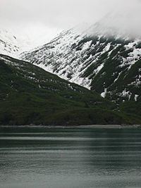
Yakutat bay hubbard glacier alaska
Yakutat Bay is a 29-km-wide (18 mi) bay in the U.S. state of Alaska, extending southwest from Disenchantment Bay to the Gulf of Alaska. "Yakutat" is a Tlingit name reported as "Jacootat" and "Yacootat" by Yuri Lisianski in 1805.
Contents
- Yakutat bay hubbard glacier alaska
- Map of Yakutat Bay Alaska USA
- Glacier bay yakutat bay coral princess alaska june 13th 14th 2013
- Other names
- References
Map of Yakutat Bay, Alaska, USA
Yakutat Bay was the epicenter of two major earthquakes on September 10, 1899, a magnitude 7.4 foreshock and a magnitude 8.0 main shock, 37 minutes apart.
The Shelikhov-Golikov company, precursor of the Russian-American Company, under the management of Alexander Andreyevich Baranov, settled Yakutat Bay in 1795. It was known as New Russia, Yakutat Colony, or Slavorossiya.
Glacier bay yakutat bay coral princess alaska june 13th 14th 2013
Other names
Yakutat Bay has had various names.
References
Yakutat Bay Wikipedia(Text) CC BY-SA