
Country Laos Area 16,358 km2 | Capital Phonsavan Population 240,591 | |
Xiangkhouang (Lao: ???????, meaning "Horizontal City") is a province of Laos, located in the Xiangkhouang Plateau, north-east of the country. Originally known as Muang Phouan, the present capital of the province is Phonsavan. The population of the province as of March 2005 census is 229,521.
Contents
Map of Xiangkhouang Province
Xiangkhouang Province covers an area of 15,880 square kilometres (6,130 sq mi) and has largely a mountainous topography. The province borders Luang Prabang Province to the northwest, Houaphan Province to the northeast, Vietnam to the east, Bolikhamsai Province to the southeast, and Vientiane Province to the southwest. Apart from floodplains, the largest area of level land in the country is located in the provinces Xiangkhouang Plateau. This area is characterized by rolling hills and grassland whose altitude averages 4,250 feet (1,300 m). The countrys highest peak, Phou Bia (9,252 feet (2,820 m)), rises at the southern side of the plateau. Nam Et-Phou Louey is a National Biodiversity Conservation Area (NBCA) in the province which covers a total area of 5,959 km2, and overlaps into Houaphan and Luang Prabang provinces.
Xiangkhouang Province is one of the main maize producing areas of Laos. It was heavily bombed during the Vietnam War era. The Plain of Jars site has been proposed for listing as a the UNESCO World Heritage Monument.
History
While the origin of the Plain of Jars people is unknown, the recorded history of Xieng Khouang is interlinked with the Tai Phuan. As an ancient civilization, its prehistory is linked to the enigmatic megalithic stone jars of the Plain of Jars (with prehistoric material recorded to the period of even 2000 BC, with Iron Age period of 500 BC and 500–800 AD period dominating the archaeological finds) representing burial grounds of ritualistic practices with extended history spread from Angkor period to the Hindu and Buddhist religious impacts. The Tai Phuan or Phuan people are a Buddhist Tai-Lao ethnic group that migrated to Laos from southern China and by the 13th century had formed the independent principality Muang Phuan at the Plain of Jars with Xieng Khouang (the contemporary Muang Khoun) as the capital. They prospered from the overland trade in metals and forest products with India and China. In the mid-14th century, Muang Phuan was incorporated into the Lan Xang Kingdom under King Fa Ngum.
The Xieng Khouang Plateau has been surmised, based on archaeological finds of Bronze and Iron Age of the period between 500 BC and 500 AD, as the center of trade representing a large area of upland Southeast Asia covering Vietnam, Samrong Sen in Cambodia, and the Khorat Plateau in northeast Thailand, Danang City in Laos, and the North Cachar Hills of northeastern India.
According to the Pongsawadan Meuang Puan or the Muang Puan Chronicles, the Tai Puan, a Buddhist Tai-Lao ethnic group, are said to be the first people who migrated in the 13th century from China and settled in this province; they had established trade in metals and forest produce and consequently were prosperous. During the mid 14th century they were subsumed into the Lan Xang Kingdom. The Siamese wars in the 18th and 19th centuries resulted in the Tai Puans loss of freedom.
In subsequent years the Haw invaders from China ravaged the province and also Luang Prabang by looting. the Franco-Siamese treaties of In the 1890s came under French colonial rule under Treaty of French Indochina, which extended to a short period beyond World War II. During the Second Indochina War of the 1960s and 70s there was more suffering to the people of the province due to the Laotian Civil War between the Royalist and the Pathet Lao until the 1975 when the Pathet Lao took power. Xiangkhouang was the province most bombed by the USAF airplanes in support of the Royalist forces. As a result of this extended war, Muong Khoun, the original capital of the province suffered much damage due to bombing by the USAF and resulted in shifting of the capital to Phonsavanh. During this war, most of the temples built in the period from the 16th and 19th century were destroyed except for the Vat Pia Vat temple. The royalist were led by General Vang Pao, who was born in the province, during the war in the 1960s.
Geography
Xiangkhouang Province covers an area of 15,880 square kilometres (6,130 sq mi) and has largely a mountainous topography. The province borders Luang Prabang Province to the northwest, Houaphan Province to the northeast, Vietnam to the east, Bolikhamsai Province to the southeast, and Vientiane Province to the southwest. The capital is Phonsavan. Xiangkhouang and Vientiane Provinces are part of the Nam Ngum watershed.
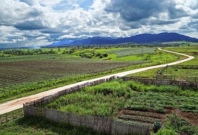
Apart from floodplains, the largest area of level land in the country is located in the provinces Xiangkhouang Plateau. This area is characterized by rolling hills and grassland whose altitude averages 4,250 feet (1,300 m). The countrys highest peak, Phou Bia (9,252 feet (2,820 m)), rises at the southern side of the plateau, while the Plain of Jars is in the plateaus center.
The province is 400 km northeast of Vientiane. Phu Bia at 2700 m elevation is the highest peak in the province, and also the highest in Laos. The capital city is at an elevation of about 1,000 m.s.l with Kham district situated in a low-laying basin at an elevation of about 600 m.s.l.
Economy
Xiangkhouang Province is one of the main maize producing areas of Laos. The main centre for trade and tourism is Phonsavan. In the village of Ban Napia near Phonsavan, villagers re-use UXO scrap metal to make spoons to be sold as souvenirs. The war scrap metal is checked for safety beforehand by UXO Lao. This community based project provides valuable income for the villagers. As of 2012, 3 minor accidents involving the UXO metal had been reported.