Neha Patil (Editor)

Xgħajra

Updated on
Edit
Like
Comment
Share on FacebookTweet on TwitterShare on LinkedInShare on Reddit
Country
  
Borders
  
Kalkara, Żabbar

Area
  
100 ha

Population
  
1,732 (Mar 2014)

Time zone
  
CET (UTC+1)

Postal code
  
XJR

Local time
  
Friday 7:36 PM

Xgħajra httpsuploadwikimediaorgwikipediacommonsthu

District
  
Southern Harbour District

Demonym(s)
  
Xgħajri (m), Xgħajrija (f), Xgħajrin (pl)

Weather
  
16°C, Wind E at 10 km/h, 75% Humidity

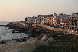
Xgħajra (Maltese: Ix-Xgħajra) is a small village in the South Eastern Region of Malta. It is located on the coast, about halfway between Valletta and Marsaskala. Its local football club is known as the Xghajra Tornadoes F.C. Contrary to popular belief, it has no connection to the Gozitan village known as Xagħra. Its population stood at 1732 in March 2014.

Contents

Map of Xg%C4%A7ajra, Malta

Local Council

The current local council members are:

  • Attard, Neil (vici Sindku)- PL
  • Valvo, Anthony (Sindku) - PL
  • Azzopardi, Joseph k/a Ġużi- PL
  • Buttigieg, Antonia k/a Nina - PL
  • Borġ, Doris - PN
  • Zones in Xgħajra

  • San Pietru
  • Ta' Alessi
  • Ta' Maġġi
  • Tal-Qassisin
  • Tan-Nisa
  • Tumbrell
  • Wied Glavan
  • Xgħajra Main Roads

  • Dawret ix-Xatt (Strand By-Pass)
  • Triq Ħaż-Żabbar (Zabbar Road)
  • Triq il-Fortizza tal-Grazzja (Grazzia Fort Street)
  • Triq il-Knisja (Church Street)
  • Triq it-Torri ta' Alof de Wignacourt (Alof de Wignacourt Tower Street). This road refers to the Santa Maria delle Grazie Tower that Knights of Malta erected in 1620 during the reign of Grand Master Fra Alof de Wignacourt, which was one of the set of Wignacourt towers. The British demolished the tower to clear a field of fire for the Della Grazie Battery that they constructed in 1888.
  • References

    Xgħajra Wikipedia


    Similar Topics