
River system Rhine Discharge 1.4 m³/s | Reference no. DE: 2828 Length 53 km Source elevation 270 m Mouth Rur | |
 | ||
Main source South of Aachen265 m above sea level (NN) Basin size 355.518 km (137.266 sq mi) River mouth North of Heinsberg into the Rur; 32 m above sea level (NN); 51°05′52″N 6°06′23″E / 51.097722°N 6.106250°E | ||
Das fl chen wurm bei geilenkirchen the river worm
The River Wurm (Dutch: Worm) is a river in the state of North Rhine-Westphalia in western Germany. It rises in the Eifel mountains and flows for 57 kilometres before discharging into the River Rur.
Contents
- Das fl chen wurm bei geilenkirchen the river worm
- Angeln auf schen und bachforelle am bach mit wurm 19 05 2016
- Geography
- References
Angeln auf schen und bachforelle am bach mit wurm 19 05 2016
Geography
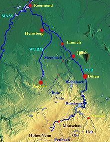
The Wurm is a left (western) tributary of the River Rur (Roer River). The Rur becomes a tributary of the Meuse River.
The sources of the Wurm are several brooks in the forests southwest of Aachen, which form the Wurm after the Diepenbenden reservoir. From there the Wurm nowadays flows through canals through the city of Aachen, until it resurfaces at the Europaplatz in the east of Aachen. North of Aachen (between Kerkrade and Herzogenrath) the river forms the border with the Netherlands for approx. 10 km. It flows into the River Rur near Heinsberg.
Other towns on the river Wurm are Würselen, Übach-Palenberg and Geilenkirchen.
The name Wurm is thought to originate from the German word warm (same meaning in English), as the source brooks were fed from the thermal springs in Aachen.