
OS grid reference ST975574 Unitary authority Dialling code 01380 Population 624 (in 2011) | Civil parish Worton Sovereign state United Kingdom UK parliament constituency Devizes | |
 | ||
Worton is a village and civil parish about 3 miles (5 km) southwest of Devizes in Wiltshire. It is near the northern edge of Salisbury Plain in central southern England.
Contents
Map of Worton, UK
History
The first recorded mention of Worton was in a document of 1173.
Until 1894 Worton (and neighbouring Marston) were part of Potterne parish.
Geography
The Bulkington Brook forms the southwestern boundary of the parish. The village is elongated, set around the main High Street. Marston is just to the south, and Potterne is to the east, where the A360 road passes.
Notable landmarks
Christ Church, the Church of England parish church, was built in 1841 to designs of T.H. Wyatt and is Grade II listed.
There is a small Methodist chapel at Marston. Worton had a larger chapel, built in 1849 to replace an earlier chapel; it closed in the 1990s.
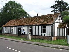
The village hall serves Worton and Marston. Worton has a pub, the Rose and Crown, which is a Grade II listed 17th-century building.
Five Lanes Primary School has two sites, with younger children at Potterne and older children at Worton. The school at Worton was built in 1965 and replaced a school which began as a Sunday school in 1844.