
OS grid reference SY371957 Local time Wednesday 6:02 PM Population 345 | Sovereign state United Kingdom | |
 | ||
Weather 13°C, Wind NW at 16 km/h, 66% Humidity | ||
The barn at champernhayes wootton fitzpaine dorset
Wootton Fitzpaine is a village and civil parish in the county of Dorset in South West England. It lies approximately 3 miles (4.8 km) north-east of Lyme Regis in a small side valley of the River Char, close to the Marshwood Vale. The civil parish covers an area of 3,307 acres (1,338 ha) and includes the ecclesiastical parish and small settlement of Monkton Wyld to the west. In the 2011 census the civil parish had 180 dwellings, 134 households and a population of 345.
Contents
- The barn at champernhayes wootton fitzpaine dorset
- Map of Wootton Fitzpaine Bridport UK
- Wootton Fitzpaine village
- Monkton Wyld village
- Footpaths and trails
- References
Map of Wootton Fitzpaine, Bridport, UK
Wootton Fitzpaine village
Wootton Fitzpaine village consists primarily of two small centres: a larger western part comprising the village hall and about 50 densely placed houses, and a smaller eastern part comprising about a dozen houses, the church and manor house. The village is sited on Middle Lias and greensand and has a history of being agriculturally relatively prosperous.
The village name derives from 'Wodetone', meaning a farm close to a wood, plus the name of the manorial family, Fitzpaine.
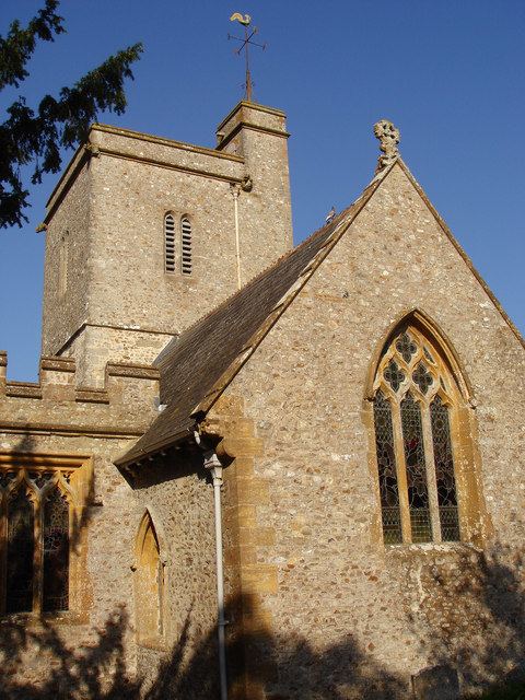
The parish church was built mostly between the 13th and 15th centuries but was restored and added to in 1872. It lies within the grounds of the adjacent Wootton House, a three-storey brick-built house constructed around 1765 but also restored and added to in the late 19th century. The rectory dates from the end of the 15th century. Twenty structures within the parish are listed by English Heritage for their historic or architectural interest.
Monkton Wyld village
50.76286°N 2.94044°W / 50.76286; -2.94044
The church is dedicated to St Andrew, it was designed by Richard Cromwell Carpenter. The largest building in this hamlet is Monkton Wyld Court, a Grade II listed Victoria Gothic former rectory built in 1848. It was also designed by Carpenter. It offers terraced south facing lawns, a dairy farm and an organic walled kitchen garden. The building was used between 1940 and 1982 as a residential school and is now run by a community as an educational centre for sustainable living.
Footpaths and trails
The Wessex Ridgeway and Monarch's Way long-distance footpaths pass through the parish, as does the Liberty Trail, a more local designated way.