
OS grid reference SO594003 Postcode district GL | Sovereign state United Kingdom Population 1,206 (2011) | |
 | ||
Woolaston is a village and civil parish in the Forest of Dean district of Gloucestershire in South West England. It lies on the north side of the Severn Estuary approximately 5 miles (8 kilometres) from the Welsh border at Chepstow and is surrounded by woodland and agricultural land.
Contents
- Map of Woolaston Lydney UK
- The village and its inhabitants
- Development of the village
- Governance
- St Andrews Church
- Stroat Evangelical Church and ruined Bible Christian chapel
- References
Map of Woolaston, Lydney, UK
The village and its inhabitants
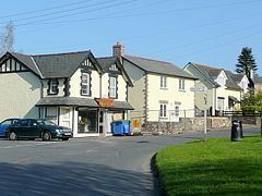
The centre of population in Woolaston is around the Netherend area to the east of the parish, very close to Alvington. Here there is a thriving primary school, two pubs, a small post office (within the village shop) and a new memorial hall, [1] a popular skate park and a community orchard. The small shop has undergone substantial re-development and is under local ownership. Changing patterns of employment and home occupation have changed the character of rural villages in this area. In bygone years there were several more shops, a blacksmith and more, but they are all long gone now as the character of the village changes. Today a substantial proportion of the village commute because the village is well placed to serve the housing needs of those who work in the Forest of Dean and also in Chepstow, Bristol, Newport and even as far as Cardiff and even London. An increasing proportion of the village's residents, repeating something of the pattern of history, are working from home, however, nowadays they are supported by network technologies rather than the fields or local industries. The older agricultural population is becoming increasingly replaced by a newer population of office based professionals, many working in of for the design, media, computer and communication industries based in the cities of Bath, Bristol and Cardiff and Newport. A well regarded village school continues to thrive and has a reputation for its art and the academic attainment of its pupils.
At one time the parish of Woolaston stretched between the River Severn and the River Wye, but now it does not (though it is still quite large). It used to contain much of the area now in the Hewelsfield and Brockweir civil parish. The Woolaston parish contains many smaller hamlets including Netherend, Woolaston Common, High Woolaston, Woolaston Woodside, Woolaston Slade, Common Wood, Lancaut, Stroat, Keynsham, Plusterwine, Brookend, Smallbrook, Clap-Y-Ates and Clanna.
There is also a boarding kennels situated at the end of Station Road, off the A48 towards the River Severn.
Development of the village
There are plans to develop the dairy into a small housing development. Recent developments have consolidated rather than expanded the village.
If you travel north west from Netherend you pass a Methodist church, then 'Birchwood Road', leading to a popular housing estate, the 'Ring Fence' a small lane with a number of cottages along it, the 'Rising Sun' one of the village's two public houses and the village allotments.
Woolaston Common is about 1 mile from the main A48 road and north of the main village. Here there is a small hamlet of houses and an area of common ground which, for the most part of the year, is covered in bracken. Adjoining the common is also another hamlet called Sandtumps.
Governance
The village falls in the 'Hewelsfield and Woolaston' electoral ward. This ward stretches from Brockweir in the north east to Woolaston. The total population of the ward taken at the 2011 census was 1,690.
St. Andrew's Church
St. Andrew's parish church at Woolaston is about a mile south west of Netherend along the A48 towards Chepstow. The earliest record of its existence is in 1131. However, the old circular churchyard and the nearby Roman road, which ran just to the north-west of the church, suggest a much earlier holy site. The Tower was originally a low one with a short wooden steeple, but following the granting of a faculty in 1774, it was completely rebuilt. It was threatened with closure in 2007 but at the final Midnight Mass on Christmas Eve it was announced the Church will be saved. There is a famous house opposite it.
Stroat Evangelical Church and ruined Bible Christian chapel
Stroat Evangelical Church (Stroat Mission) is located three miles out of Woolaston on the A48 towards Chepstow. It has been involved in the village of Woolaston for over 120 years.
There is a derelict Bible Christian chapel, built in 1836, on Woodside Road, near its junction with Slade Road.