
Postcode(s) 4210 Postal code 4210 State electorate(s) Albert | Population 1,103 (2011 census) | |
 | ||
Location 25 km (16 mi) NW of Southport68 km (42 mi) SSW of Brisbane | ||
Wongawallan is a rural locality in City of Gold Coast, Queensland, Australia. In the 2011 census, Wongawallan had a population of 1,103 people.
Contents
Map of Wongawallan QLD 4210, Australia
Geography
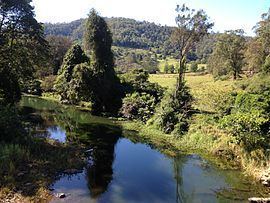
Wongawallan is mountainous terrain with most farming and residential development occurring the creek valleys. The hilltops are largely undeveloped. The main creeks are Wongawallan Creek and Tamborine Creek. Tamborine Creek joins Wongawallan creek at 27°53′59″S 153°15′00″E close to Welch Pioneer Park. Wongawallan Creek is a tributary of the Coomera River; their confluence is in neighbouring Maudsland.
The Tamborine-Oxenford Road is the main road to and through the locality.
History
The area was originally named Mt Goulburn after Henry Goulburn by surveyor Dixon. However, later it was renamed Wongawallan, believed to be an Aboriginal word where wonga means pigeon and walla means water. However, it has been claimed that it was named after an Aboriginal man nicknamed "Peter" who killed John Wilkinson, a settler, at Wongawallan Creek in 1876., but contemporaneous newspaper reports of the death of Wilkinson only refer to the Aboriginal man as "Peter".