
Constituencies 25 Area 9.36 km² | ||
 | ||
University Buddhist Hung Sean Chau Memorial College Points of interest Wong Tai Sin Temple, Chi Lin Nunnery, Nan Lian Garden, Lion Rock Country Park, Lion Rock | ||
Wong Tai Sin District (Chinese: 黃大仙區; Cantonese Yale: Wòhngdaaihsīn kēui) is one of the 18 districts of Hong Kong. It is the only fully landlocked district in Hong Kong. It is located in Kowloon.
Contents
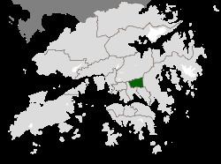
Map of Wong Tai Sin District, Hong Kong
Geography
The district contains the areas of Diamond Hill, Wang Tau Hom, Lok Fu, Chuk Yuen, Wong Tai Sin, Tsz Wan Shan, Fung Wong, Choi Hung and Choi Wan, an area that includes several major public housing estates.
Demographics
Wong Tai Sin District has a population of 444,630 (2001 figures). The district has the least educated residents with the lowest income, the oldest residents and the second highest population density. Over 85% of the district's residents live in public housing.
Religion
The district derives its name from the Wong Tai Sin Temple, dedicated to Wong Tai Sin, which is located there. The district is also the location of the Chi Lin Nunnery, built in the Tang Dynasty style, a popular tourist attraction.
Education
Schools in Wong Tai Sin District include:
Transport
Wong Tai Sin is served by Lung Cheung Road and the Kwun Tong Line of the MTR metro system. The stations are Lok Fu, Wong Tai Sin, Diamond Hill and Choi Hung.