Rahul Sharma (Editor)

Wolfschlugen

Updated on
Edit
Like
Comment
Share on FacebookTweet on TwitterShare on LinkedInShare on Reddit
Country
  
Germany

Admin. region
  
Stuttgart

Elevation
  
371 m (1,217 ft)

Area
  
7.12 km²

Population
  
6,266 (31 Dec 2008)

Dialling code
  
07022

State
  
Baden-Württemberg

District
  
Esslingen

Time zone
  
CET/CEST (UTC+1/+2)

Local time
  
Wednesday 4:50 AM

Postal code
  
72649

Administrative region
  
Stuttgart

Wolfschlugen

Weather
  
3°C, Wind NE at 2 km/h, 97% Humidity

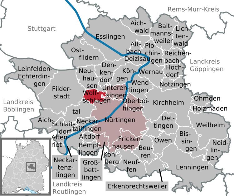
Wolfschlugen is a town in the district of Esslingen in Baden-Württemberg in southern Germany.

Contents

Map of Wolfschlugen, Germany

History

Wolfschlugen was mentioned for the first time on April 2, 1318. A man named Benz from Kirchheim sold some products of his farm in Wolfschlugen. But people settled there before, therefore evidence are remains of an old Latin estate in a forest nearby Wolfschlugen

  • 1380 the town became official by a declaration of Eberhard II, Count of Württemberg.
  • 1603 the Protestant church became reconstructed and obtained his actual form which can be seen today.
  • 1608/09 construction of the town hall by Michel Knell and Jerg Mercklin.
  • 1776 construction of the first school.
  • 1866 foundation of the fire department.
  • 1899 first telegraph office.
  • 1903 foundation of the music society.
  • 1906 first telephone connection.
  • 1914 first electrical lights on the streets.
  • 1938 Wolfschlugen became a member of the district of Nürtingen.
  • 1970 dedication of the festival hall and the sports field.
  • 1973 in case of the liquidation of the district of Nürtingen the municipality became a member of the district of Esslingen.
  • 1993 dedication of the new sports hall.
  • Number of residents

    The numbers of inhabitants are census results (¹) or official data from statistical office, Stuttgart.

    References

    Wolfschlugen Wikipedia