
Length 46 mi (74 km) | Use Hiking/Biking/Horses | |
 | ||
Trailheads Gulf JunctionSouth Citrus SpringsHolderHernandoInvernessFloral CityIstachattaRidge ManorTrilbyOwensboro Junction Hazards Steep embankments, swampland | ||
Withlacoochee State Trail is a 46-mile (74 km) long paved, multi-use, non-motorized rail trail in Florida located in Citrus, Hernando and Pasco counties. It follows along the Withlacoochee River and passes through the Withlacoochee State Forest. It is the longest paved rail trail in Florida.
Contents
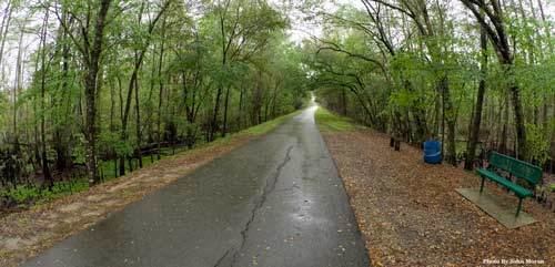
Map of Withlacoochee State Trail, Florida, USA
History
The original railroad line was formed sometime in the 1880s as the Inverness and Brooksville railway. It connected with the Florida Northern Railroad in Citrus Springs and with the South Florida Railroad (SFR) in Dade City.
In 1892, the Silver Springs, Ocala and Gulf Railroad (SSO&G) built an extension through Inverness and Hernando, and in 1893 the Atlantic Coast Line Railroad (ACL) acquired the SFR as well as the SSO&G. In 1946 ACL built a bridge over the Seaboard Air Line Railroad tracks and the newly aligned US 301.
In 1967, the Atlantic Coast Line and Seaboard Air Line Railroads merged to form the Seaboard Coast Line Railroad. In 1987 CSX decided to abandon the 47 mile railroad. In 1989 the state bought the railroad for their "rail-to-trails" program.
The route
The southern terminus is at U.S. 98/301 south of Trilby. The trail goes 6 miles (9.7 km) north to a crossover of U.S. 98/SR 50, a mile east of I-75 and 40 miles (64 km) north past the Silver Lake Campground in the Withlacoochee State Forest, close to the Withlacoochee River. The trail runs under I-75 as it continues north through Nobleton, Istachatta, and then crosses the Hernando-Citrus County Line into Pineola, the site of the Great Train Wreck of 1956.
As it enters Floral City, it runs much closer to and parallel to US 41. South of Inverness across from Citrus County Speedway and the Inverness Airport, there is a paid access trail leading to Fort Cooper State Park. Within Inverness itself, the trail runs under State Road 44, with access trails on both sides running east. North of there, the trail runs through Cooter Pond Park, Wallace Brooks Park and Liberty Park, then uses a former railroad bridge over a section of Lake Henderson. Beneath the bridge under US 41, another trail leads to Whispering Pines Park. In Hernando, the trail is briefly detoured around County Road 486 for one block, then resumes its use of the former railroad right-of-way as it continues through Holder, and Citrus Springs, where it finally ends at Gulf Junction just south of Dunnellon.
However, County Road 486 has been widened and a multi-use path follows it west until it hits County Road 491, and connected to State Road 44 by the end of 2013. The state of Florida has just approved funding for the Coast to Coast Connector, some of which will include connecting the Withlacoochee State Trail to the Claridoma-Ocoee Connector Trail in Lake County, which will then connect all the way to the east coast, terminating on Merritt Island. The Coast to Coast Connector will also connect the Withlacoochee State Trail to the Suncoast Trail, which follows the Suncoast Parkway south to Tampa.
Parking
Parking for the trail is located off U.S. 98/301 at the Owensboro Junction Trailhead, C.R. 575 / Trilby Trailhead, S.R. 50 Trailhead, Silver Lake Campground, Townsen Lake Regional Park off C.R. 476, Desoto Trail Kiosk off U.S. 41, Wallace Brooks Park and Liberty Park in Inverness, South Citrus Springs Trailhead and Gulf Junction Trailhead, both of which are in Citrus Springs.
Hours
Florida state parks are open between 8 a.m. and sundown every day of the year (including holidays).