
OS grid reference TQ143142 Post town STEYNING Area 13.6 km² Dialling code 01903 Population 221 2001 Census | Civil parish Wiston Postcode district BN44 Sovereign state United Kingdom UK parliament constituency Arundel and South Downs | |
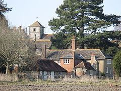 | ||
Wiston is a scattered village and civil parish in the Horsham District of West Sussex, England. It lies on the A283 road 2.8 miles (4.5 km) northwest of Steyning.
Contents
Map of Wiston, UK
The parish covers an area of 1,360 hectares (3,400 acres). In the 2001 census 221 people lived in 86 households, of whom 120 were economically active.
Landmarks
Chanctonbury Ring, a hill fort based ring of trees atop Chanctonbury Hill on the South Downs, lies on the border of the parish and the neighbouring parish of Washington. Chanctonbury Hill is a Site of Special Scientific Interest as an uncommon woodland type on a chalk escarpment, providing habitat for many species including the protected Great Crested Newt.
References
Wiston, West Sussex Wikipedia(Text) CC BY-SA