
Area 1,049 km² Population 40,589 (2013) | Website www.wisecounty.org Founded 1856 Unemployment rate 8.3% (Apr 2015) | |
 | ||
Colleges and Universities University of Virginia's College at Wise, Mountain Empire Community College Points of interest | ||
Wise County is a county located in the U.S. state of Virginia. As of the 2010 census, the population was 41,452. Its county seat is Wise. The county was formed in 1856 from Lee, Scott, and Russell Counties and named for Henry A. Wise, who was the Governor of Virginia at the time.
Contents
- Map of Wise County VA USA
- History
- Geography
- Major highways
- National protected area
- Demographics
- Public schools
- Private schools
- Colleges and universities
- Newspapers
- Radio Stations
- Natural and outdoor recreation
- Theater and the arts
- Festivals and fairs
- Historical
- Sports
- Communities
- Towns
- Census designated place
- References
Map of Wise County, VA, USA
History
The Cherokee conquered the area including Wise from the Xualae between 1671 and 1685. It was later contested by the Six Nations and the Shawnee. A Cherokee hunting party fought a protracted battle with a Shawnee one at the headwaters of the Clinch River for two days in the summer of 1786, a victory for the Cherokee although losses were heavy on both sides.
The first white explorers to have reached present-day Wise county are said to have been Thomas Walker and Christopher Gist, both in 1750. Several forts were built all along the Clinch from 1774 onward, but only after Chickamauga Cherokee leader Bob Benge was slain in 1794 was present-day Wise considered safe for white settlers even to hunt in. Among the earliest settlers within the county was William Wells in around 1792.
Virginia's two highest security state prisons are located in Wise County: Red Onion State Prison, opened in 1998, and Wallens Ridge State Prison, opened in 1999.
Geography
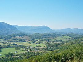
According to the U.S. Census Bureau, the county has a total area of 405 square miles (1,050 km2), of which 403 square miles (1,040 km2) is land and 2 square miles (5.2 km2) (0.5%) is water. The county is part of the Appalachians and has many mountainous features, including the peak of High Knob and Powell Valley.
Major highways
National protected area
Demographics
As of the census of 2010, there were 41,452 people, 15,968 households, and 10,892 families residing in the county. The population density was 102.8 people per square mile (38/km²). There were 17,940 housing units at an average density of 44 per square mile (17/km²). The racial makeup of the county was 93% White, 5.2% Black or African American, 0.10% Native American, 0.30% Asian, 0.01% Pacific Islander, and 0.90% from two or more races. 1.10% of the population were Hispanic or Latino of any race.
There were 15,968 households out of which 31.80% had children under the age of 18 living with them, 50,30% were married couples living together, 12.60% had a female householder with no husband present, and 31.80% were non-families. 27.40% of all households were made up of individuals and 11.40% had someone living alone who was 65 years of age or older. The average household size was 2.40 and the average family size was 2.90.
In the county, the population was spread out with 20.80% under the age of 18 and 14.10% who were 65 years of age or older. The median age was 39 years. For every 100 females there were 107 males. For every 100 females age 18 and over, there were 107.08 males.
The median income for a household in the county was $35,053. The per capita income for the county was $17,512. About 19.30% of the population were below the poverty line. The homeownership rate for the county is 70.00%
Public schools
Wise County Public Schools operates seventeen school facilities in the county for over 7,000 students. For several years the Wise County School Board has considered consolidating high school, and in 2011 it closed its three smallest high schools and consolidate them into the three largest high schools.
Private schools
Wise County Christian School operates as a private school in the county.
Colleges and universities
Newspapers
Radio Stations
Natural and outdoor recreation
A large portion of the Jefferson National Forest is contained within Wise County, and the Clinch River winds through the county. These two factors, combined with Wise County's location in the Appalachian Mountains, mean that Wise County offers many opportunities for outdoor recreation.
In addition to many trails connecting to and surrounding the Appalachian Trail system, Wise county is home to many parks, including Miners' Park in Big Stone Gap and the Louis E. Henegar Miners' Memorial Park in Appalachia.
Among the unique features of Wise County are High Knob, a mountain which featured one of the last remaining Appalachian Fire Towers until its destruction by arson on October 31, 2007, and Wetlands Estonoa, an Appalachian Wetland and part of the Clinch River Watershed.
Theater and the arts
Festivals and fairs
Historical
Sports
UVa-Wise hosts NCAA Division II Football, Basketball, Baseball and other inter-collegiate games on the campus of UVa-Wise.