
Country United States County Kennebec Time zone Eastern (EST) (UTC-5) Zip code 04364 Population 6,092 (2010) | Settled 1765 Area code(s) 207 Incorporated 1771 | |
 | ||
Weather 2°C, Wind SE at 13 km/h, 85% Humidity | ||
Winthrop is a town in Kennebec County, Maine, United States. The population was 6,092 at the 2010 census. Winthrop's population, however, approximately doubles during the summer months as part-year residents return to seasonal camps located on the shores of Winthrop's Lakes and Ponds. A recreational area located among lakes, the town includes the villages of Winthrop and East Winthrop, and is the center of the Winthrop Lakes Region. Winthrop is included in the Augusta, Maine Micropolitan New England City and Town Area.
Contents
- Map of Winthrop ME USA
- History
- Villages and neighborhoods
- Geography
- Demographics
- 2010 census
- Education
- Local government
- Political makeup
- Sites of interest
- Winthrop Lakes Region
- Notable people
- References
Map of Winthrop, ME, USA
History
Winthrop was part of the Kennebec Purchase awarded by the Plymouth Council for New England. First called Pondtown for its lakes and ponds, it was settled by Timothy Foster in 1765. On April 26, 1771, Pondtown Plantation was incorporated by the Massachusetts General Court as Winthrop, named for the first colonial governor of Massachusetts, John Winthrop. Readfield was set off and incorporated in 1791. The surface of the town is uneven, but with good land that yielded hay, grain and apples. Winthrop became noted for its orchards and cattle.
At the outlet of Maranacook Lake into Annabessacook Lake, John Chandler built a sawmill in 1768, and then added a gristmill. Other industries followed, including a fulling mill, tannery and blacksmith shop. The Winthrop Woolen & Cotton Manufactory was incorporated in 1809, and in 1814 went into operation. By 1886, the town had a sawmill which manufactured about 200,000 feet of lumber every year, two oil cloth factories, a sash and blind factory, and a foundry and machine shop. The Maine Central Railroad opened to the village, carrying freight and tourists. Winthrop and its lakes developed into a summer resort, which it remains today.
Villages and neighborhoods
Winthrop has historically referred to its regions by directional names. Other than Winthrop Village and East Winthrop, their boundaries are not firmly established and tend to vary from person to person. Winthrop has several villages and areas that can be classified as neighborhoods. Some of them are:
Geography
Winthrop is an industrial and suburban center, located about 10 miles west of Maine's capital city, Augusta. Nearly 10% of Winthrop's housing is seasonal. The commercial downtown is situated between Maranacook and Annabessacook Lake.
According to the United States Census Bureau, the town has a total area of 37.90 square miles (98.16 km2), of which 31.22 square miles (80.86 km2) is land and 6.68 square miles (17.30 km2) is water. Winthrop is drained by Hoyt Brook.
The town is crossed by U. S. Route 202 and state routes 11, 41, 100, 133 and 135. It is bordered by the towns of Manchester to the east, West Gardiner to the southeast, Monmouth to the south, Leeds and Wayne to the west, and Readfield to the north.
Winthrop is also home to Mt. Pisgah (pronounced piss-gah, from the Hebrew word for summit or lookout), which is 807 ft above sea level and home to the Maine Fire Services watch tower that was in service from 1949 to 1992, when air patrols rendered it obsolete. The tower still stands to this day and is accessible by a hiking trail.
Demographics
As of 2000 the median income for a household in the town is $58,066, and the median income for a family is $64,637. Males have a median income of $35,262 versus $27,130 for females. The per capita income for the town is $27,755. 9.2% of the population and 5.0% of families are below the poverty line. Out of the total population, 13.8% of those under the age of 18 and 17.8% of those 65 and older are living below the poverty line.
Winthrop has historically been known as a fast-growing suburban town, and saw its population triple during the 20th century. Its growth rate has slowed in recent years, and saw a decline in the 2010 census for the first time in almost a century. Winthrop has always been the largest in population municipality in Kennebec County that is classified as a Town and not a City. Oakland surpassed Winthrop's population in the 2010 census.
2010 census
As of the census of 2010, there are 6,092 people, 2,598 households, and 1,740 families residing in the town. The population density is 195.3 people per square mile (75.5/km²). There are 3,295 housing units at an average density of 105.6 per square mile (40.8/km²). The racial makeup of the town is 97.6% White, 0.3% Black or African American, 0.2% Native American, 0.3% Asian, and 1.4% from two or more races. 1.0% of the population are Hispanic or Latino of any race.
There are 2,598 households of which 28.2% have children under the age of 18 living with them, 52.3% are married couples living together, 10.1% have a female householder with no husband present, and 33% are non-families. 26.9% of all households are made up of individuals and 9.5% have someone living alone who is 65 years of age or older. The average household size is 2.31 and the average family size is 2.76.
In the town, the population is spread out with 22.3% under the age of 20, 9% from 20 to 29, 17.1% from 30 to 44, 34.2% from 45 to 64, and 17.1% who are 65 years of age or older. The median age is 46 years. The female population was 51.6% and male population 48.4%.
Education
Winthrop Public Schools is an independent school district serving approximately 840 students in grades PK-12. Winthrop's schools are governed by the Winthrop Board of Education. The five-member group consists of elected representatives from Winthrop. The members serve two-year terms and conduct monthly meetings that are open to the public. Winthrop operates 3 schools:
Winthrop is also home to the Monmouth/Winthrop Adult Education.
Local government
Winthrop uses the Council-Manager form of government, in which the Town Council is the primary governing authority. The Winthrop Town Council consists of seven elected members. The Town Council appoints and confirms both the Town Manager, and the Town Attorney. The Town Manager, in turn, appoints the Finance Director, and Clerk. In addition to these positions, Winthrop has several departments used to provide the services necessary to the town.
The framework for the town government is defined in the Municipal charter.
Political makeup
Winthrop is known as being politically moderate, and consistently votes for both liberals and conservatives for local, state, and national offices. In the 2008 Presidential election, Barack Obama received 2,006 of the town's votes to John McCain's 1,569, and in the 2004 Presidential election, John Kerry received 50% of the town's votes to George W. Bush's 47.4%, compared to 53% for Kerry and 45% for Bush statewide. In 2009 the town voted in favor of a statewide referendum to overturn a state law allowing same-sex marriage in Maine by a vote of 2,349 to 1,277, but voted in 2012 on a referendum to allow same-sex marriage 53% to 47%. The town has more Independent voters than it does Democrats or Republicans:
Voter registration
Sites of interest
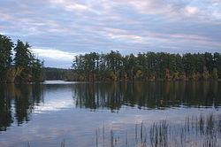
Winthrop Lakes Region
Winthrop is at the center of the Winthrop Lakes Region, which is situated between Lewiston and Augusta, Maine, and centered around six major bodies of water: Androscoggin Lake, Annabessacook Lake, Cobbosseecontee Lake, Echo Lake, Maranacook Lake and Parker Pond, in addition to numerous smaller bodies of water. Besides Winthrop, the region includes the towns of Fayette, Readfield, and Mount Vernon to the north, Manchester to the east, Monmouth to the south, and Wayne to the west. The northern part of Mount Vernon is considered to be part of the Belgrade Lakes Region. The region is a popular recreation area in central Maine, with over three dozen Lakes and ponds offering a variety of boating, hiking, cycling, camping and fishing opportunities. The area is also home to numerous shoreline events, concerts and festivals.
The Winthrop Lakes Region includes the following bodies of water:
*Cobbosseecontee Lake (known locally as Cobbossee) is nationally recognized as one of the top bass-fishing lakes in America due to its impressive largemouth population. Cobbossee also has the only active inland waters lighthouse in Maine, Ladies Delight Light.