
Status Operational Length 1,140 m (3,740 ft) Opened 1974 Dam volume 573 m3 (20,200 cu ft) | Opening date 1974 Height 19 m Catchment area 40 km² Surface area 625 ha (1,540 acres) | |
 | ||
Spillway capacity 520 m/s (18,000 cu ft/s) Similar Spring Creek Dam, Fitzroy Falls Dam, Balmain Reservoir, Winburndale Dam, Gosling Creek Dam | ||
Raw footage wingecarribee dam nsw australia
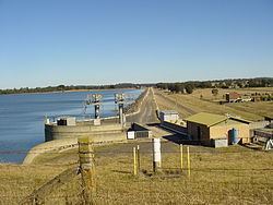
Wingecarribee Dam, completed in 1974 as part of the Shoalhaven Scheme, is an earth and rockfill embankment dam structure located on the Wingecarribee River about 15 kilometres (9.3 mi) southeast of Bowral in New South Wales, Australia. The embankment of 573 cubic metres (20,200 cu ft) is 19 metres (62 ft) high and 1,140 metres (3,740 ft) in length. At 100% capacity, the dam wall holds back approximately 25,875 megalitres (913.8×10^6 cu ft) and creates the impounded reservoir of Wingecarribee Reservoir that has a surface area of 625 hectares (1,540 acres), drawn from a catchment area of 40 square kilometres (15 sq mi). The spillway has a discharge capacity of 520 cubic metres per second (18,000 cu ft/s). Wingecarribee Reservoir lost around 9,000 megalitres (320×10^6 cu ft) of storage capacity as a result of the inflow of peat from the Wingecarribee Swamp collapse in August 1998. The original storage capacity was 34,500 megalitres (1,220×10^6 cu ft).