
Country Australia Opening date 1974 Impounds Yarrunga Creek Height 14 m Catchment area 31 km² | Status Operational Length 1,530 m (5,020 ft) Opened 1974 Impound Yarrunga Creek | |
 | ||
Similar Wingecarribee Dam, Toonumbar Dam, Balmain Reservoir, Carcoar Dam, Spring Creek Dam | ||
Aerial survey of fitzroy falls dam
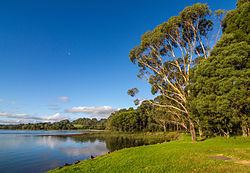
Fitzroy Falls Dam in New South Wales, Australia, is part of the Shoalhaven Scheme, completed in 1974. It consists of four separate earth and rockfill embankments located on the Yarrunga Creek upstream of Fitzroy Falls and about 16 kilometres (9.9 mi) southeast of Moss Vale. The main embankment of 760 cubic metres (27,000 cu ft) is 14 metres (46 ft) high and 1,530 metres (5,020 ft) in length. At 100% capacity, the dam wall holds back approximately 9,950 megalitres (351×10^6 cu ft) of water, creating the impounded Fitzroy Falls Reservoir, which has a surface area of 522 hectares (1,290 acres), drawn from a catchment area of 31 square kilometres (12 sq mi). The spillway has a discharge capacity of 516 cubic metres per second (18,200 cu ft/s).
The 3,030-metre (9,940 ft) Wildes Meadow Canal connects the reservoir to the Burrawang Pumping Station. The 2,830-metre (9,280 ft) Burrawang Tunnel and 1,000-metre (3,300 ft) Canal join the pumping station to the Wingecarribee Reservoir.
Another canal links the reservoir to the Bendeela Pondage via the Bendeela Pumping and Power Station. This allows the Fitzroy Falls dam to both act as a storage pond for hydroelectric power generation, and to move water from the Tallowa Dam to the Wingecarribee and Warragamba catchments.