
Population 315 2001 Census Unitary authority Area 4.507 km² | OS grid reference SK893033 Ceremonial county Rutland Local time Tuesday 11:27 AM Dialling code 01572 | |
 | ||
Weather 13°C, Wind NW at 14 km/h, 77% Humidity | ||
Wing is a small village and civil parish in the county of Rutland in the East Midlands of England. The population at the 2001 census was 315, reducing marginally to 314 at the 2011 census.
Contents
- Map of Wing UK
- Architecture
- Etymology
- Turf maze
- Waterworks
- Public houses
- Buildings and structures
- Notable people
- References
Map of Wing, UK
Architecture
The 17th-century houses in Wing were built from stone quarried at nearby Barnack and Clipsham. Many are roofed with Collyweston stone slate.
The church, dedicated to Saint Peter and Saint Paul, was much rebuilt in 1875, at which time the spire was removed. Some parts of the building date from Norman times, including the south arcade of about 1150, the slightly later north arcade and the north doorway.
Etymology
Its name first occurs as Wenge in the 12th century, and probably came from Old Norse vengi = "field".
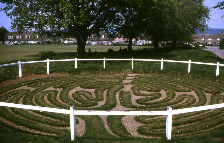
Turf maze
Beside Glaston Road, cut in the turf by the roadside, is a circular "turf maze" (actually a unicursal labyrinth, roughly 40 ft (12 m) in diameter), is said to date back to medieval times, based on the fact that its design is similar to the pavement maze in Chartres cathedral and other medieval examples.
Waterworks
A treatment plant just outside the village treats water extracted from Rutland Water reservoir a few miles to the north. Proposals by Anglian Water to extend the works, and increase the volume of drinking water extracted from the lake, were strongly opposed by the RSPB on the grounds that fluctuating water levels could potentially damage wildfowl habitats around the lake.