
Length 72,000 m Use Hiking | Trailhead Bowness-on-Windermere Designation National Trails | |
 | ||
Location Northern England, United Kingdom Trailheads Bowness-on-Windermere, Cumbria Highest point Wansfell, 1,601 ft (488 m) Similar Orrest Head, Holehird Gardens, Windermere, Wansfell, Gummer's How | ||
The windermere way hd
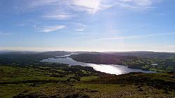
The Windermere Way is a 45-mile circuit of Windermere, a lake in the English Lake District. The route is wholly within the Lake District National Park and takes in the summits of Wansfell, Loughrigg Fell and Gummer's How as well as passing through the towns of Ambleside and Windermere.
Contents
History and status
The Windermere Way is an unofficial route and mostly follows footpaths and bridleways. There are short stretches of road walking. The route can be broken down into four easy stages with an easy return to your starting point using the Windermere Ferry or the Lake Steamers.
Route
The walk circumambulates Windermere and includes just about all the accessible lake shore paths together with ascents of the high points around the lake.
The route is broken down into four sections that most people will manage in a day’s easy walking. The Windermere to Ambleside walk starts at Bowness Bay and follows the lake shore northwards before ascending Orrest Head, dropping down again to cross Trout Beck then taking to the high fell tops, visiting Wansfell Pike the highest point on the walk.
Between Ambleside and Ferry House, the walk starts by climbing Loughrigg Fell, then drops down again past Loughrigg Tarn and on to a pleasant lakeside stroll by Wray Castle. It then climbs steeply again, to give views from Claife Heights, finishing at Ferry Nab.
Between Ferry Nab and Lakeside the route passes through Cunsey and winds along the western shore of Windermere, visiting High Dam at Finsthwaite before concluding at Lakeside Steamer Pier.
The final stretch from Lakeside back to Bowness is the longest and doesn't touch the lakeshore at all, but does afford some excellent views from Gummer's How and lovely walking through the woods.
Connecting trails
The route connects with the Dales Way at Bowness and Cumbria Way at Skelwith Bridge.
Places of interest
The following hills are crossed by the route:
The following lakes and tarns are passed by the route: