
- left East Fork Wind River - elevation 4,472 ft (1,363 m) Length 298 km Basin 7,730 sq mi (20,021 km2) | - elevation 9,760 ft (2,975 m) Basin area 20,021 km² Source Wind River Lake | |
 | ||
- right Dinwoody Creek, Bull Lake Creek, Little Wind River - location Wedding of the Waters, Hot Springs County | ||
The Wind River is the name applied to the upper reaches of the Bighorn River in Wyoming in the United States. The Wind River is 185 miles (298 km) long. The two rivers are sometimes referred to as the Wind/Bighorn.
Contents
Map of Wind River, Wyoming, USA
CourseEdit
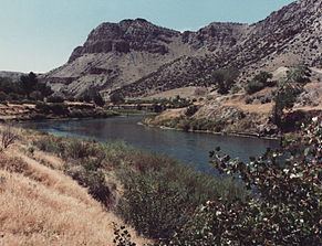
Its headwaters are at Wind River Lake in the Rocky Mountains, near the summit of Togwotee Pass (pronounced toe-go-tee) and gathers water from several forks along the northeast side of the Wind River Range in west central Wyoming. It flows southeastward, across the Wind River Basin and the Wind River Indian Reservation and joins the Little Wind River near Riverton. Up stream from this confluence, it is known locally as the Big Wind River. It flows northward, through a gap in the Owl Creek Mountains, where the name of the river becomes the Bighorn River. In the Owl Creek Mountains, it is dammed to form Boysen Reservoir. The Wind River officially becomes the Bighorn River at the Wedding of the Waters, on the north side of the Wind River Canyon.