
OS grid ST165352 Prominence 263 m Parent peak Dunkery Hill | Elevation 386 m Topo map OS Landranger 181 | |
 | ||
Similar Staple Hill, Selworthy Beacon, Lewesdon Hill, Pilsdon Pen, Pen Hill | ||
Wills Neck is the highest summit on the Quantock Hills and one of the highest points in Somerset, England. Although only 1261 ft (384 m) high, it qualifies as one of England's Marilyns. It is situated about 8 miles (13 km) north west of the historic market town of Taunton.
Map of Wills Neck, Taunton, UK
The name 'Wills Neck' is derived from the Saxon word for 'stranger' or 'foreigner'. It relates to a local tribe the Wealas which according to legend fought the Romans at the site.
On a clear day it is possible to see Dartmoor, Exmoor, the Brecon Beacons, the Mendips and Blackdown Hills. It is sometimes even possible to see Pilsdon Pen, the highest point in Dorset.
The hill is formed from Hangman Grits laid down during the Devonian a geologic period of the Paleozoic Era spanning from the end of the Silurian Period, about 419.2 Mya (million years ago), to the beginning of the Carboniferous Period.
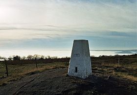
Wills Neck was surveyed by schoolboys from Clifton College from 1922 and 1945, led by teacher William Cornish Badcock. They built a cairn at the highest point which has now been replaced, on exactly the same spot, by a modern Trig point.
A beer brewed by the Quantock Brewery has been named Wills Neck after the hill.