
Prominence c. 47 m OS grid ST564488 | Elevation 305 m | |
 | ||
Topo map OS Landrangers 182, 183 Similar Cadbury Hill, Knowle Hill, Dundry Hill, Black Down - Dorset, Wills Neck | ||
Pen Hill forms part of the Mendip Hills plateau in Somerset, England. The hill is located in St Cuthbert Out civil parish in Mendip district.
Map of Pen Hill, Wells, UK
The name Pen is believed to be Celtic for hill or tor. It gives its name to one of the four periclines which underlay the geology of the hills.
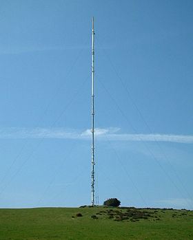
The summit is 305 metres (1,001 ft) above sea level and is marked by an Ordnance Survey trig point. It is the second highest point on the Mendip Hills. Pen Hill is home to the Mendip TV Mast which is 281 metres (922 ft) high. On the ground Pen Hill provides spectacular views in all directions, particularly to the south, with excellent views down to the City of Wells and Wells Cathedral (approximately 2 miles (3.2 km) distant). On clear day it is often possible to see across Somerset to the Blackdown Hills, Quantock Hills and Brendon Hills.
There are ancient remains on the hill, in the form of a neolithic Long barrow, which has been listed as Scheduled Ancient Monument, and a post medieval pillow mound thought to have been built specifically for rabbit breeding.