
- elevation 4,351 ft (1,326 m) - average 31.3 cu ft/s (0.9 m/s) Discharge 0.8863 m³/s Basin area 2,279 km² Mouth Columbia River | - elevation 269 ft (82 m) Length 127 km Basin area 2,279 km² Source Arbuckle Mountain Road | |
 | ||
- location Blue Mountains, Morrow County, Oregon - location upstream of Arlington, Gilliam County, Oregon - max 16,900 cu ft/s (478.6 m/s) (January 14, 1974) | ||
Willow Creek is a 79-mile (127 km) long tributary of the Columbia River, located in the U.S. state of Oregon. It drains 880 square miles (2,279 km2) of Morrow and Gilliam counties. Arising in the Blue Mountains, it flows generally northwest to its confluence with the Columbia River upstream of Arlington.
Contents
CourseEdit
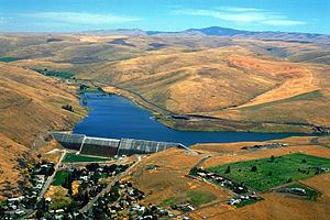
Willow Creek's headwaters are located near Arbuckle Mountain in the Blue Mountains, southeast of Heppner. It flows north, then west, receiving the North Fork on the right and Skinners Fork on the left. Willow Creek Lake is formed by the 160-foot (49 m) tall Willow Creek Dam just upstream of Heppner at river mile (RM) 52.4, or river kilometer (RK) 84.3. Willow Creek flows northwest through Heppner, receiving Hinton Creek on the right. About 10 miles (16 km) later, the creek travels through Lexington. Soon after, Rhea Creek enters on the left, and Willow Creek passes through the communities of Ione and Morgan. Turning north, it crosses into Gilliam County, flowing beneath Highway 74 and Interstate 84/Highway 30 just before its mouth. Willow Creek flows into the Columbia River approximately 253 miles (407 km) above its confluence with the Pacific Ocean.
WatershedEdit
Willow Creek drains 880 square miles (2,279 km2) of the Columbia Plateau region of Oregon. Ninety percent is privately owned, nine percent is owned by U.S. federal agencies such as the United States Forest Service, Bureau of Land Management, and United States Department of Defense, and one percent is owned by the state of Oregon. About 60 percent of the watershed is either forested, rangeland, or shrubland, 39 percent is cropland, and 1 percent is urban. The highest elevation in the watershed is 5,583 feet (1,702 m) near Willow Creek's headwaters, while the lowest is 269 feet (82 m) at its mouth. Temperatures range from below 0 °F (−18 °C) to over 110 °F (43 °C), while the average is about 50 °F (10 °C). The average precipitation ranges from 8 inches (203 mm) in the lower regions to 34 inches (864 mm) in the mountains.
FishEdit
No anadromous fish are known to inhabit streams in the Willow Creek watershed. Small and Largemouth Bass, Black Crappie, Brown Bullhead, Bluegill, and Pumpkinseed live in Willow Creek Lake.
HistoryEdit
Strong thunderstorms moved over the Heppner area on June 14, 1903, causing heavy rain and hail. Within fifteen minutes, a 40-foot (10 m) wall of water swept down Willow Creek. The flash flood washed away one-third of the town's structures, killing 247 people in the "most deadly natural disaster in Oregon's recorded history." One hundred and fifty homes were destroyed in the city of Ione, 20 miles (30 km) downstream; residents were able to evacuate because of advanced telephone warnings. In 1983, the Willow Creek Dam was constructed just upstream of Heppner. The resulting Willow Creek Lake's primary use is flood control.