
Elevation 1 m (3 ft) Postcode 1230–1244, 1394, 3625 Area 76.55 km² Local time Sunday 11:47 PM | Established 1 January 2002 Time zone CET (UTC+1) Area code 0294, 035 | |
 | ||
Weather 9°C, Wind N at 11 km/h, 88% Humidity Points of interest Kasteel Sypesteyn, Sluis Het Hemeltje, Fort Kijkuit | ||
Wijdemeren ( pronunciation ) is a municipality in the Netherlands, in the province of North Holland, on the western border of Het Gooi region.
Contents
Map of Wijdemeren, Netherlands
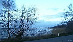
Wijdemeren contains many lakes. In the north(east) Spiegelplas and Ankeveense Plassen, in the (south)west Loosdrechtse Plassen.
Population centres
The municipality of Wijdemeren consists of the following cities, towns, villages and/or districts: Ankeveen, Boomhoek, Breukeleveen, 's-Graveland, Kortenhoef, Muyeveld, Nederhorst den Berg, Nieuw-Loosdrecht, Oud-Loosdrecht.
Dutch Topographic map of the municipality of Wijdemeren, 2013.
References
Wijdemeren Wikipedia(Text) CC BY-SA