
Type lake Basin countries Poland Max. width 0.452 km (0.281 mi) Surface elevation 1,665 m Primary outflow Roztoka | Primary outflows Roztoka Max. length 0.998 km (0.620 mi) Surface area 3.414 km (1.318 sq mi) Area 3.414 km² | |
 | ||
Similar Tatra Mountains, Przedni Staw Polski, Siklawa, Zadni Staw Polski, Wodogrzmoty Mickiewicze | ||
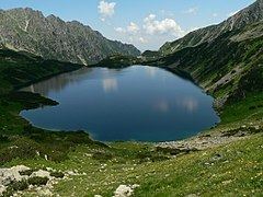
Wielki Staw Polski (Polish: Wielki Staw Polski; Slovakian: Veľký stav; German: Großer See; Hungarian: Nagy-tó) - is a tarn located in the High Tatras, at an elevation of 1,665 metres above sea level in the Valley of the Five Polish Lakes (Dolina Pięciu Stawów Polskich), by the slope of the Miedziane. The lake is the second-largest lake by area (34.14 hectares (84.4 acres)) in the Tatra Mountains after the Morskie Oko (34.54 hectares (85.4 acres)). The lake is located in the Lesser Poland Voivodeship; in Poland.
Map of Wielki Staw, Poland
Wielki Staw Polski is the deepest and longest (998 metres) lake in the Tatra Mountains, and the third-deepest lake in Poland (the deepest lake is Hańcza. The lake's volume is around 13 million m³ of water, and it is the largest lake by volume in the Tatra Mountains (its volume makes up one third of all lakes in the Tatra Mountains lakes). The highest temperature of the lake's water was 11.2 °C (52.2 °F).