
Total islands 74 Area 275.1 km² | Archipelago Whitsunday Islands Island group Whitsunday Islands | |
 | ||
Local government area Whitsunday Regional Council | ||
The whitsunday islands travel deeper australia ep 6
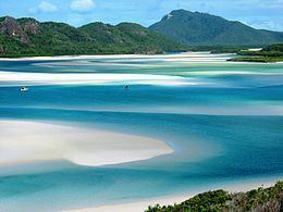
Whitsunday Island is the largest island in the Whitsunday group of islands located off the coast of Central Queensland, Australia. Whitehaven Beach was rated as the top Eco Friendly Beach in the world by CNN.com in July 2010. The island should not be confused with Pinaki in the Tuamotu group which was named "Whitsunday Island" by Samuel Wallis in 1767. It is uninhabited today but was once settled by the sea-faring Ngaro people.
Contents
- The whitsunday islands travel deeper australia ep 6
- Whitehaven beach whitsunday islands australia
- Geography
- References
Whitehaven beach whitsunday islands australia
Geography
The island is accessible by boat from the mainland tourist ports of Airlie Beach and Shute Harbour. It contains many popular destinations for both day visitors and overnight sailors, including the magnificent pure-white sands of Whitehaven Beach and Hill Inlet, the secure anchorage of Cid Harbour, and the sheltered waterway of Gulnare Inlet. The island has six campgrounds.
Named by Captain James Cook in early June 1770, the island covers 27,508 ha (275.08 km2) in area. Around the northern bays of the island are seagrass beds which support a diverse range of marine life. Unadorned rock-wallabies are found on the island.
The seas here are warm, clear, shallow, nutrient rich and fast moving due to large tiday flows making them well-suited to the growth of fringing coral reefs.