
Country United States County Lake Incorporated (Town) 1895 Zip code 46394 Population 4,891 (2013) | State Indiana Incorporated (City) 1903 Local time Sunday 7:09 AM | |
 | ||
Weather 7°C, Wind S at 3 km/h, 53% Humidity University | ||
Today in america whiting indiana
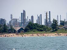
Whiting is a city located in the Chicago Metropolitan Area in Lake County, Indiana, which was founded in 1889. The city is located on the southern shore of Lake Michigan. It is roughly 16 miles from the Chicago Loop and two miles from Chicago's South Side. Whiting is home to Whiting Refinery, the largest oil refinery in the Midwest. The population was 4,997 at the 2010 census.
Contents
- Today in america whiting indiana
- Map of Whiting IN USA
- Paul goddard whiting indiana frozen lake ice shelves whihala beach january 14th 2017
- History
- Geography
- 2010 census
- 2000 census
- Parks
- Education
- Transportation
- Notable people
- References
Map of Whiting, IN, USA
Paul goddard whiting indiana frozen lake ice shelves whihala beach january 14th 2017
History
A post office was first established at Whiting in 1871. Whiting was incorporated in 1895.
The Hoosier Theater Building and Whiting Memorial Community House are listed in the National Register of Historic Places.
Geography
According to the 2010 census, Whiting has a total area of 3.229 square miles (8.36 km2), of which 1.8 square miles (4.66 km2) (or 55.74%) is land and 1.429 square miles (3.70 km2) (or 44.26%) is water.
The Whiting post office (46394) serves not only the city of Whiting, but also the adjacent Hammond neighborhood of Robertsdale, immediately to the west. Addresses in this Hammond neighborhood show “Whiting, Indiana.” While not legally a part of the city of Whiting, locally the area has long been informally considered to be a culturally integrated part of Whiting. References to Whiting businesses or residents often include those technically from Hammond’s Robertsdale.
2010 census
As of the census of 2010, there were 4,997 people, 1,899 households, and 1,210 families residing in the city. The population density was 2,776.1 inhabitants per square mile (1,071.9/km2). There were 2,197 housing units at an average density of 1,220.6 per square mile (471.3/km2). The racial makeup of the city was 76.3% White, 3.5% African American, 0.7% Native American, 0.7% Asian, 15.7% from other races, and 3.2% from two or more races. Hispanic or Latino of any race were 40.7% of the population.
There were 1,899 households of which 37.1% had children under the age of 18 living with them, 38.1% were married couples living together, 18.6% had a female householder with no husband present, 7.0% had a male householder with no wife present, and 36.3% were non-families. 30.1% of all households were made up of individuals and 11.3% had someone living alone who was 65 years of age or older. The average household size was 2.63 and the average family size was 3.32.
The median age in the city was 34.4 years. 26.9% of residents were under the age of 18; 9.4% were between the ages of 18 and 24; 27.3% were from 25 to 44; 24.7% were from 45 to 64; and 11.6% were 65 years of age or older. The gender makeup of the city was 49.1% male and 50.9% female.
2000 census
As of the census of 2000, there were 5,137 people, 2,091 households, and 1,281 families residing in the city. The population density was 2,914.1 people per square mile (1,126.9/km²). There were 2,313 housing units at an average density of 1,312.1 per square mile (507.4/km²). The racial makeup of the city was 87.37% White, 0.56% African American, 0.29% Native American, 0.91% Asian, 0.08% Pacific Islander, 9.09% from other races, and 1.69% from two or more races. Hispanic or Latino of any race were 25.56% of the population.
There were 2,091 households out of which 30.5% had children under the age of 18 living with them, 41.3% were married couples living together, 15.0% had a female householder with no husband present, and 38.7% were non-families. 33.8% of all households were made up of individuals and 13.8% had someone living alone who was 65 years of age or older. The average household size was 2.46 and the average family size was 3.18.
In the city, the population was spread out with 26.0% under the age of 18, 8.5% from 18 to 24, 30.7% from 25 to 44, 19.7% from 45 to 64, and 15.0% who were 65 years of age or older. The median age was 36 years. For every 100 females there were 92.0 males. For every 100 females age 18 and over, there were 93.1 males.
The median income for a household in the city was $34,972, and the median income for a family was $40,994. Males had a median income of $33,565 versus $21,981 for females. The per capita income for the city was $17,518. About 10.1% of families and 12.3% of the population were below the poverty line, including 19.5% of those under age 18 and 9.1% of those age 65 or over.
Parks
Whiting is home to five parks. Whiting Park, located on the Lake Michigan shoreline, is the most well known. It is a popular picnic spot for residents of Lake County, the South Side of Chicago, and Southland. Whihala Beach is located next to Whiting Park between Whiting and neighboring Hammond.
Education
School City of Whiting serves Whiting. Whiting High School is the sole public high school serving Whiting. The city is also home to a historic Carnegie Library, built in 1905. Whiting Public Library is located at 1735 Oliver Street. Calumet College of St. Joseph is a private college affiliated with the Roman Catholic Church through the Missionaries of the Precious Blood. Its main campus is in Whiting, Indiana, with additional campuses located in Chicago, Illinois, and Merrillville, Indiana. The college was founded in 1951 as an extension of Saint Joseph's College in Rensselaer, Indiana and currently enrolls 1,262 students.
Transportation
Amtrak's Wolverine line stops at Hammond–Whiting station in nearby Hammond.
Airports serving Whiting are Chicago's O'Hare International Airport, Midway International Airport, and Gary/Chicago International Airport located in Gary, Indiana.