
Nearest city Alamogordo, New Mexico Architect Lyle E. Bennett | Built 1936 Architectural style Pueblo Revival | |
 | ||
Area 143,733 acres (581.67 km) Website White Sands National Monument | ||
White Sands National Monument is a U.S. National Monument located in the state of New Mexico on the north side of Route 70 about 16 miles (26 km) southwest of Alamogordo in western Otero County and northeastern Doña Ana County. The monument is situated at an elevation of 4,235 feet (1,291 m) in the mountain-ringed Tularosa Basin and comprises the southern part of a 275 sq mi (710 km2) field of white sand dunes composed of gypsum crystals. The gypsum dune field is the largest of its kind in the world.
Contents
HistoryEdit
The first exploration was led by a party of US Army officers in 1849. The Mescalero Apache were already living in the area at the time. Hispanic families started farming communities in the area at Tularosa in 1861 and at La Luz in 1863.
Preparation for a National ParkEdit
Creating a national park in the white sands formation goes back as far as 1898. A group in El Paso had proposed the creation of "Mescalero" National Park. Their idea was for a game hunting preserve, which conflicted with the idea of preservation held by the Department of the Interior, and their plan was not successful. In 1921-1922 Albert Bacon Fall, United States Secretary of the Interior and owner of a large ranch in Three Rivers near White Sands, promoted the idea of a national park there, an "All-Year National Park" that, unlike more northerly parks, would be usable year-round. This idea ran into a number of difficulties and did not succeed. Tom Charles, an Alamogordo insurance agent and civic booster, was influenced by Fall's ideas. By emphasizing the economic benefits, Charles was able to mobilize enough support to have the park created.
On January 18, 1933, President Herbert Hoover created the White Sands National Monument, acting under the authority of the Antiquities Act of 1906. The dedication and grand opening was on April 29, 1934.
Life as a National MonumentEdit
Tom Charles became the first custodian of the monument, and upon his retirement in 1939 became the first concessionaire, operating as White Sands Service Company.
The Headquarters building (also called the Visitor Center Complex) was constructed of adobe bricks as a Works Progress Administration project starting in 1936 and completed in 1938.
The Monument is completely surrounded by military installations (White Sands Missile Range and Holloman Air Force Base) and has always had an uneasy relationship with the military. Errant missiles often fell on WSNM property, in some cases destroying some of the visitor areas. Overflights from Holloman disturbed the tranquility of the area.
In 1969 the New Mexico Department of Game and Fish introduced oryx into the Tularosa Basin, intending them to be hunted for sport. The oryx had no natural predators; they invaded WSNM and competed with the native species for forage.
In 1996, increasingly problematic alcohol abuse by students on spring break led to a ban of alcohol use in the monument during the months of February to May.
World Heritage Site controversyEdit
WSNM was placed on the Tentative List of World Heritage Sites on January 22, 2008. The state's two U.S. Senators, Pete Domenici and Jeff Bingaman, wrote letters of support of the application. U.S. Representative Stevan Pearce declined to support the application, saying, "I would guarantee that if White Sands Monument receives this designation, that there will at some point be international pressures exerted that could stop military operations as we know them today."
The WHS application generated much controversy in Otero County, most of it taking place in meetings of the Otero County Commission. A petition with 1,200 signatures opposing the application was presented to the Commission on August 16, 2007. The Commission on August 23, 2007 passed a resolution of opposition to the application, and on October 18, 2007 passed Ordinance 07-05 that purports to make it illegal for WSNM to become a World Heritage Site. On January 24, 2008, after the Tentative List was announced, the Commission instructed the County Attorney to write a letter to the Secretary of the Interior, demanding that WSNM be taken off the list.
DescriptionEdit
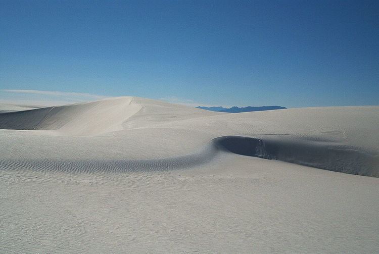
Gypsum is rarely found in the form of sand because it is water-soluble. Normally, rain would dissolve the gypsum and carry it to the sea. The Tularosa Basin is enclosed, meaning that it has no outlet to the sea and that rain that dissolves gypsum from the surrounding San Andres and Sacramento Mountains is trapped within the basin. Thus water either sinks into the ground or forms shallow pools which subsequently dry out and leave gypsum in a crystalline form, called selenite, on the surface. Groundwater that does flow out of the Tularosa Basin flows south into the Hueco Basin. During the last ice age, a lake known as Lake Otero covered much of the basin. When it dried out, it left a large flat area of selenite crystals which is now the Alkali Flat. Another lake, Lake Lucero, at the southwest corner of the park, is a dry lake bed, at one of the lowest points of the basin, which occasionally fills with water.
The ground in the Alkali Flat and along Lake Lucero's shore is covered with selenite crystals which reach lengths of up to three feet (1 m). Weathering and erosion eventually breaks the crystals into sand-size grains that are carried away by the prevailing winds from the southwest, forming white dunes. The dunes constantly change shape and slowly move downwind. Since gypsum is water-soluble, the sand that composes the dunes may dissolve and cement together after rain, forming a layer of sand that is more solid and could affect wind resistance of dunes. This resistance does not prevent dunes from quickly covering the plants in their path. Some species of plants, however, can grow fast enough to avoid being buried by the dunes.
Various forms of dunes are found within the limits of White Sands. Dome dunes are found along the southwest margins of the field, transverse and barchan in the core of the field, and parabolic dunes occur in high numbers along the northern, southern, and northeastern margins. From the visitor center at the entrance of the park, the Dunes Drive leads 8 miles (13 km) into the dunes. Four marked trails allow one to explore the dunes by foot. During the summer, there are also Ranger-guided orientation and nature walks. The park participates in the Junior Ranger Program, with various age-group-specific activities [1].
Unlike dunes made of quartz-based sand crystals, the gypsum does not readily convert the sun's energy into heat and thus can be walked upon safely with bare feet, even in the hottest summer months. In areas accessible by car, children frequently use the dunes for downhill sledding. Because the park lies completely within the White Sands Missile Range, both the park and U.S. Route 70 between Las Cruces, New Mexico and Alamogordo are subject to closure for safety reasons when tests are conducted on the missile range. On average, tests occur about twice a week, for a duration of one to two hours. Located on the northernmost boundaries of White Sands Missile Range, the Trinity Site can be found, where the first atom bomb was detonated.