
Existed: 1950s – present Length 114.6 km | West end: Mineral Bottom Road | |
 | ||
East end: Shafer Trail; Potash Road Similar Canyonlands National Park, Island in the Sky Visitor Ce, Mesa Arch, Upheaval Dome, Grand View Point Overlook | ||
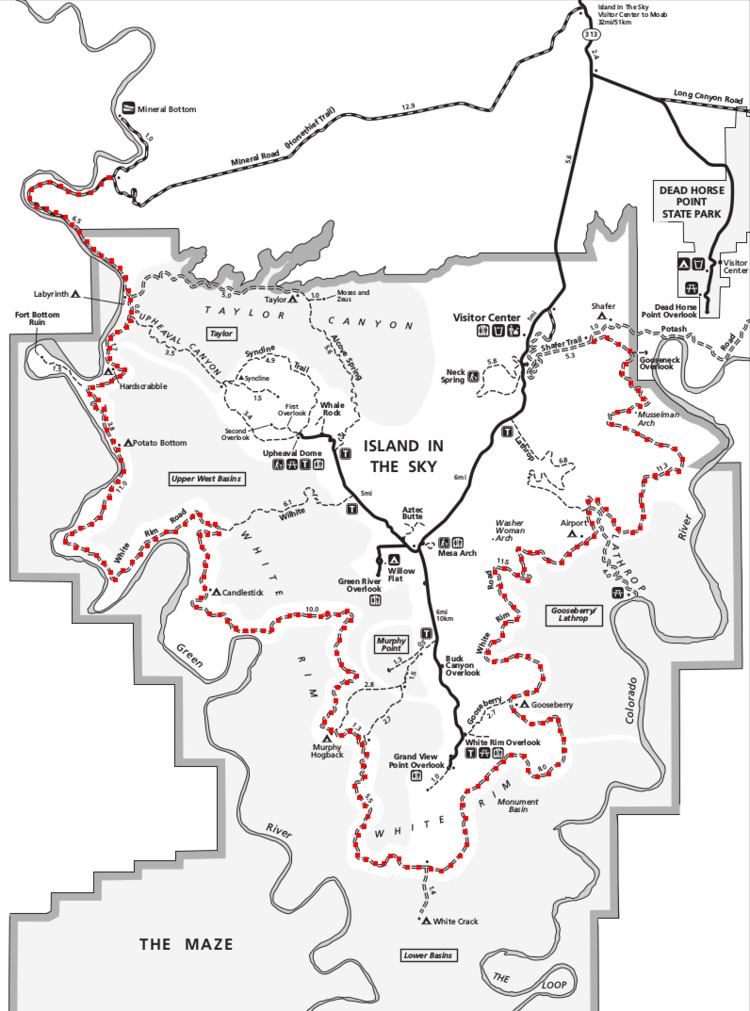
The White Rim Road is a 71.2-mile-long (114.6 km) unpaved four-wheel drive road that traverses the top of the White Rim Sandstone formation below the Island in the Sky mesa of Canyonlands National Park in southern Utah in the United States. The road was constructed in the 1950s by the Atomic Energy Commission to provide access for individual prospectors intent on mining uranium deposits for use in nuclear weapons production during the Cold War. Large deposits had been found in similar areas within the region; however, the mines along the White Rim Road produced very little uranium and all the mines were abandoned.
Contents
Map of White Rim Rd, Moab, UT 84532, USA
The road surface consists of loose dirt, sandy dry washes and sandstone rock formations. Four-wheel drive vehicles and mountain bikes are the most common modes of transport though horseback riding and hiking are also permitted. Typical excursions at a modest pace take two days by four-wheel drive vehicle and three days by mountain bike. Street-legal, registered motorbikes are also permitted to travel on the road. The National Park Service (NPS), which administers the park and maintains the road, recommends bicyclists have a motorized support vehicle to carry extra water. No potable water is available anywhere along the road and there are few river access points. The Green River is accessible at spots along the western end of the road but Lathrop Canyon is the only access point to the Colorado River near the eastern terminus. Hikers may access the White Rim from the Island in the Sky by hiking down steep trails leading to seven points along the road.
Roads leading to the White Rim Road are Mineral Bottom Road, also called Horsethief Trail, in the park's west side and Shafer Trail in the park's east side. Both roads are junctions off the Island in the Sky park road, which is an extension of Utah State Route 313. A shorter alternate from Moab is Potash Road—Utah State Route 279—in the east side of the park which connects at the junction of White Rim Road with Shafer Trail.
Like the Shafer Trail, White Rim Road is also sometimes referred to as a trail since a common term for a four-wheel drive road is a Jeep trail.
Features
Starting on Shafer Trail from the Island in the Sky mesa, a traveller will encounter hairpin turns, steep grades and cliffs with no guardrails. After a short distance along relatively flat terrain at the base of the mesa, the end of Shafer Trail is reached and the White Rim Road begins at the junction with Potash Road. The first river view is at the Gooseneck Overlook which offers a glimpse into the Colorado River canyon at the end of a 0.6-mile (0.97 km) round-trip hike. There is no access to the river from the cliff at the overlook. Subsequent features include Musselman Arch, Airport Tower butte and Washer Woman Arch, all visible from the road. A steep four-mile (6.4 km) spur road leads down to the Colorado River through Lathrop Canyon. Back on the White Rim Road, one passes Buck Canyon, Gooseberry Canyon and Monument Basin with its rock pinnacles, followed by the White Crack campground spur road. The next challenge occurs at the steep Murphy Hogback which marks the approximate halfway point on the road. Soon after the Hogback, the Turks Head butte appears in the middle of an oxbow bend of the Green River. Candlestick Tower and Potato Bottom are next, followed by a three-mile (4.8 km) round-trip hiking trail to Fort Bottom Ruin and then a steep, rocky section of road at Hardscrabble Hill. Finally, a five-mile (8.0 km) spur road leads to two rock towers called Moses and Zeus. After crossing sandy dry washes, or arroyos, the White Rim Road ends just outside the national park boundary at the junction with Mineral Bottom Road and its hairpin turns leading one back up to the Island in the Sky.
Permits
As of 2015, permits are required for both day-use and overnight trips along the White Rim Road. The demand for permits frequently exceeds the number available in spring and fall months, especially March, April, May, September and October. Visitors are advised to make advance reservations. A maximum of 100 day-use permits are issued per day, with 50 reserved for motorized vehicles and 50 for bicyclists. There are 25 permits of each type available as advance reservations and the other 25 available on the day of a trip. Larger groups are required to leave 30 minutes apart to minimize dust and potential convergence of several groups in one area. The limits were decided based on statistics gathered over a ten year period from 2004–14 when an average of 40 vehicles per day entered on the east side of the White Rim Road and an average of 26 vehicles per day entered on the west side. The limits are intended to provide a better wilderness experience for all visitors and minimize impacts on the natural surroundings.
During 2015–16, there are no fees for day-use of the White Rim Road but a park entrance fee is required. No permit is required for travelling Shafer Trail or Potash Road, which are the only two roads that connect to the White Rim Road on its east side. The park service is likely to institute day-use permit fees in coming years to pay for administrative costs and backcountry patrols, according to the Southeast Utah Group Superintendent for the NPS. Visitors staying overnight must stay in one of twenty campsites within ten campground areas scattered along the road and some of its spurs. All overnight stays require a backcountry permit and a $30 fee for the full stay, up to 14 consecutive nights.
Regulations
The NPS requires all motorized vehicles including motorbikes be registered, street-legal and operated by licensed drivers only. ATVs, UTVs and OHVs are not permitted. All vehicles and bicycles must remain on the road surface. Pets are not permitted regardless of whether they could be kept inside a vehicle at all times.
A high-clearance, four-wheel drive vehicle with a low gear range is required by park regulation since July 2014 on many backcountry roads including the White Rim Road. Front or rear-wheel drive only vehicles, as well as automatic all-wheel drive and low-clearance vehicles are not permitted. All drivers should be cautious at all times and be aware that towing fees usually exceed $1000 from the most remote areas. The road is rated moderately difficult for high-clearance, four-wheel drive vehicles in good weather conditions.
Horses and pack animals such as burros and mules are allowed on all backcountry roads with a permit. Day-use limits are no more than ten people and ten animals per group, and overnight limits are seven people and ten animals per group. Day-use permits are free and overnight trips incur a $30 backcountry fee. All animals must be fed only pelletized food for two days in advance of a trip and for the duration of the trip to reduce the chance of spreading non-native plant seeds through manure. No park vegetation may be consumed and all remaining food and manure must be packed out on exit.