
Quadrant NW Sector West Elevation 671 m | Ward 5 Area 75 ha Population 1,327 (2012) | |
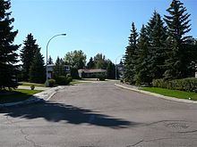 | ||
Westridge is a residential neighbourhood in west Edmonton, Alberta, Canada.
Contents
Map of Westridge, Edmonton, AB, Canada
The neighbourhood is bounded to the north and northeast by Patricia Ravine and to the south by Wolf Willow Ravine. The southeast tip overlooks the North Saskatchewan River valley. The western boundary is 170 Street. Access to the neighbourhood is exclusively by way of Wolf Willow Road.
According to the 2001 federal census, four out of five (80.2%) of the residences in Westridge were built during the 1970s. The remaining one in five (19.8%) were built during the 1980s.
Almost all of the houses in the neighbourhood (93.5%), according to the 2005 municipal census, are single-family dwellings. The remainder (6.5%) are row houses. Almost all residences in the neighbourhood are owner-occupied, with less than 1% being rented.
The north west corner of the neighbourhood is close to the 170 Street interchange with Whitemud Drive. This provides people in the neighbourhood with good access to destinations on the south side including: the University of Alberta, Fort Edmonton Park, and Old Strathcona.
West Edmonton Mall is located to the north of the neighbourhood along 170 Street. Residents also enjoy comparatively good access to the downtown core.
Demographics
In the City of Edmonton's 2012 municipal census, Westridge had a population of 1,327 living in 496 dwellings, a -6.2% change from its 2009 population of 1,415. With a land area of 0.75 km2 (0.29 sq mi), it had a population density of 1,769.3 people/km2 in 2012.