
Topo map OS Explorer | OS grid ST504045 Elevation 250 m | |
 | ||
Weston hill global investors forum whglif 2016
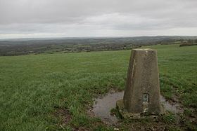
Weston Hill is a hill, 250 metres (820 ft) high, on the A 356, 1 kilometre west of Corscombe in the county of Dorset in southern England. It is located within the Dorset Downs. It is named after the hamlet of Weston to the northeast.
Contents
Map of Weston Hill, Beaminster, UK
The summit is marked by a trig point just north of the A 356, and there is a transmission mast about 100 metres to the northwest. To the east the terrain drops steeply towards Corscombe. To the southwest it descends gently to Beaminster Down before dropping sharply at Mintern's Hill towards Beaminster.
References
Weston Hill Wikipedia(Text) CC BY-SA